Public Tags
Other tags: Track Junction
category:Track Junction
Showing latest 50 of 1,016 images tagged with subject:Track Junction tag.

|
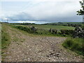
Track in the New Forest, near Ringwood
by Malc McDonald geograph for square SU1808 A junction of tracks in the Great Linford Inclosure in the New Forest National... (more)
Tags:
Cycling and Walking TrailX
Forest TrackX
Forest Track JunctionX
Forestry TrackX
Forestry Track JunctionX
type:GeographX
county:HampshireX
place:New ForestX
New ForestX
national park:New ForestX
New Forest National ParkX
top:PathsX
near:RingwoodX
TrackX
subject:Track Junction
Track Junction
Woodland TrackX
top:Woodland, ForestX
|

|
Track junction at the south west corner of Coed Cwm Kenfig
by eswales geograph for square SS8385 Category: Track junction A junction of tracks, both also footpaths, in a pleasant deciduous area on the... (more)
|

|
Track junction at Afan Forest Park
by eswales geograph for square SS8193 Category: Track junction A track junction with waymark on Mynydd Penhydd.
|

|
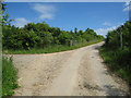
Track through Milkham Inclosure, near Ringwood
by Malc McDonald geograph for square SU2109 A wide gravel track through Milkham Inclosure in the New Forest National Park.
Tags:
Forest TrackX
Forestry Track JunctionX
type:GeographX
county:HampshireX
place:New ForestX
New ForestX
national park:New ForestX
New Forest National ParkX
top:PathsX
near:RingwoodX
Rural TrackX
TrackX
Track Junction
subject:Track Junction
Woodland TrackX
|

|
Track junction in the north of Coed Cwm Kenfig
by eswales geograph for square SS8387 Category: Track junction Although the track to the left (which continues behind the photographer's... (more)
Tags:
Cwm CynffigX
Cwm KenfigX
top:PathsX
TrackX
subject:Track Junction
Track Junction
top:Woodland, ForestX
|

|
Tracks through Milkham Inclosure, near Ringwood
by Malc McDonald geograph for square SU2110 A fork in the tracks in Milkham Inclosure in the New Forest National Park.
Tags:
Forest TrackX
Forestry Track JunctionX
type:GeographX
county:HampshireX
national park:New ForestX
place:New ForestX
New ForestX
New Forest National ParkX
top:PathsX
near:RingwoodX
Rural TrackX
TrackX
subject:Track Junction
Track Junction
Woodland TrackX
top:Woodland, ForestX
|

|
Tracks in the New Forest, near Ringwood
by Malc McDonald geograph for square SU2009 A fork in tracks through a wooded enclosure in the New Forest National Park.
Tags:
Forest TrackX
Forestry Track JunctionX
type:GeographX
county:HampshireX
near:LinwoodX
national park:New ForestX
place:New ForestX
New ForestX
New Forest National ParkX
top:PathsX
near:RingwoodX
Rural TrackX
TrackX
subject:Track Junction
Track Junction
Woodland TrackX
top:Woodland, ForestX
|

|
A fork in the tracks, near Ringwood
by Malc McDonald geograph for square SU1910 A junction of tracks in the New Forest National Park. Cycling is permitted on a... (more)
Tags:
type:GeographX
county:HampshireX
near:LinwoodX
national park:New ForestX
place:New ForestX
New ForestX
New Forest National ParkX
near:RingwoodX
top:Roads, Road TransportX
subject:Track Junction
Track Junction
TracksX
|

|
Berwickshire Landscape : View uphill to track junction on Bell Hill
by Richard West geograph for square NT8365 The newer hard track bends round to the left towards the out of sight wind... (more)
Tags:
hill:Bell Hill BerwickshireX
top:Farm, Fishery, Market GardeningX
type:GeographX
near:GrantshouseX
top:LowlandsX
top:PathsX
top:Roads, Road TransportX
TrackX
subject:Track Junction
Track Junction
Vehicle TrackX
Windfarm Access RoadX
|

|
Track junction below Meall Dubh, Glen Bruar
by AlastairG geograph for square NN8372 A rough track, shown on the 1:50 000 OS map, would appear to offer a shortcut... (more)
|

|
Junction of two tracks
by Robert Graham geograph for square NZ0751 This is the junction of a track running north from Derwent Manor Hotel with the... (more)
Tags:
Dry Stone WallX
Field PathX
type:GeographX
top:LowlandsX
top:PathsX
top:Roads, Road TransportX
Track Junction
subject:Track Junction
|

|
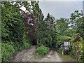
Track to The Lodge
by Mr Ignavy geograph for square SU6550 Category: Track / path junction Just beyond the trees to the right of the track is a cricket ground.
Tags:
Track / Path JunctionX
subject:Track Junction
|

|
Tracks in the New Forest, near Lyndhurst
by Malc McDonald geograph for square SU2611 A junction of tracks in the New Forest National Park.
Tags:
type:GeographX
county:HampshireX
near:LyndhurstX
national park:New ForestX
place:New ForestX
New ForestX
New Forest National ParkX
top:Roads, Road TransportX
TrackX
Track Junction
subject:Track Junction
|

|
Berwickshire Landscape : View downhill from a track junction on Bell Hill, near Grantshouse
by Richard West geograph for square NT8365 Tags:
hill:Bell Hill BerwickshireX
top:Farm, Fishery, Market GardeningX
type:GeographX
near:GrantshouseX
top:LowlandsX
top:PathsX
top:Roads, Road TransportX
TrackX
subject:Track Junction
Track Junction
Vehicle TrackX
Windfarm Access RoadX
|
|
Berwickshire Landscape : Track junction between Renton House and Renton Barns cottages
by Richard West geograph for square NT8265 The track to the left heads towards the track up Bell Hill.
The track to the... (more)
Tags:
Farm Access RoadX
top:Farm, Fishery, Market GardeningX
type:GeographX
near:GrantshouseX
top:LowlandsX
top:PathsX
near:Renton BarnsX
top:Roads, Road TransportX
subject:Track Junction
Track Junction
|

|
Tracks at Nether Row
by Adrian Taylor geograph for square NY3237 Nether Row comprises little more than a scattering of houses and a junction of... (more)
Tags:
CumbriaX
Cumbria WayX
Cumbria Way Alternative RouteX
type:GeographX
Junction of TracksX
Nether RowX
top:Roads, Road TransportX
The Cumbria WayX
long distance path:The Cumbria WayX
ldp:The Cumbria WayX
The Cumbria Way Alternative RouteX
subject:Track Junction
TracksX
top:Village, Rural SettlementX
|

|
Lane entrance near Brookside
by Adrian Taylor geograph for square SD2389 Leading from the road near Brookside the lane leads to Buttstead Wood and... (more)
|

|
Track junction
by Aleks Scholz geograph for square NN5831 Fall leaves on the tracks. This is the junction between two paths through the... (more)
Tags:
type:GeographX
top:PathsX
top:Rivers, Streams, DrainageX
subject:Track Junction
top:Woodland, ForestX
|

|
Track junction off Troed-y-rhiw Road
by M J Roscoe geograph for square ST1995 Two tracks leave the road almost opposite its junction with a byway and cross... (more)
|

|
Track junction
by David Pashley geograph for square TL7998 Track junction with Cold Harbour cottage in background.
Tags:
Breckland NorfolkX
top:Flat LandscapesX
type:GeographX
top:PathsX
Thetford ForestX
subject:Track Junction
Track Junction
top:Woodland, ForestX
|

|
Track junction
by Lairich Rig geograph for square NS5079 The junction of tracks is depicted on the 1:25000 and 1:50000 maps. The track... (more)
Tags:
type:GeographX
long distance path:John Muir WayX
top:Roads, Road TransportX
subject:Track Junction
|

|
Track junction south of Quarry Road, Ryde
by Jaggery geograph for square SZ5991 A minor track on the right diverges from the well-trodden track on the left,... (more)
|

|
Northbourne Road: junction with Lonely Lane along west side of Updown House park
by Hugh Craddock geograph for square TR3153 Turning off the Northbourne Road down a track along the west side of Updown... (more)
|
|
Parting of ways
by Mr Ignavy geograph for square SY7995 Category: Track / path junction Footpath to the left, farm track straight ahead.
Tags:
Track / Path JunctionX
subject:Track Junction
|

|
Track junction at Dormont
by Adrian Taylor geograph for square NY1175 This was originally a junction on the carriage drives to Dormont House, where... (more)
Tags:
long distance path:Annandale WayX
ldp:Annandale WayX
Annandale WayX
former:Carriage DriveX
top:Country EstatesX
DormontX
DumfriesshireX
Former Carriage DriveX
type:GeographX
Junction of TracksX
top:LowlandsX
top:Roads, Road TransportX
subject:Track Junction
|

|
Junction of tracks
by Richard Sutcliffe geograph for square NS4754 The tracks go all around Neilston Pad - a distinctive flat-topped hill of... (more)
Tags:
type:GeographX
top:Roads, Road TransportX
subject:TrackX
subject:Track Junction
top:Woodland, ForestX
|
|
Track junction at Clunbury
by Fabian Musto geograph for square SO3780 This track junction is by an old tractor, and we took the track to the left,... (more)
Tags:
top:Air, Sky, WeatherX
type:GeographX
top:PathsX
top:Roads, Road TransportX
subject:Track Junction
|

|
Forest track junction
by jeff collins geograph for square SX5260 Left hand track heads towards Ramage Wood. Right hand track comes from Cann... (more)
|

|
Track junction
by David Pashley geograph for square TL9392 Junction of forest paths with forest road 83
Tags:
Breckland NorfolkX
top:Flat LandscapesX
type:GeographX
top:PathsX
top:Roads, Road TransportX
Thetford ForestX
subject:Track Junction
Track Junction
top:Woodland, ForestX
|

|
Track Junction
by Chris Thomas-Atkin geograph for square TQ3416 A track junction beside the railway line. In the field beyond the junction new... (more)
|

|
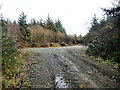
Track junction, Cwmcarn Forest
by M J Roscoe geograph for square ST2392 Junction of minor and major forestry tracks on the side of Cwm Byr.
Tags:
Conifer PlantationX
Forestry TrackX
type:GeographX
top:Roads, Road TransportX
subject:Track Junction
top:UplandsX
top:Woodland, ForestX
|

|
Track Junction towards Craig Cwm Llwch
by Alan Hughes geograph for square SO0020 High visibility track markers at the Craig Cwm Llwch / Pont ar Daf track... (more)
|

|
Track off Grove Road
by Geographer geograph for square TM1584 Tags:
top:Farm, Fishery, Market GardeningX
type:GeographX
GissingX
at:GissingX
Grove RoadX
off:Grove RoadX
top:Roads, Road TransportX
subject:TrackX
TrackX
Track Junction
subject:Track Junction
|

|
Track junction
by Lairich Rig geograph for square NS4979 The junction is depicted on the map at 1:25000 and 1:50000 scales. The John Muir... (more)
Tags:
Forestry TrackX
type:GeographX
long distance path:John Muir WayX
top:Roads, Road TransportX
subject:Track Junction
|

|
South Barrule, forestry track junction
by Mike Faherty geograph for square SC2776 Mountain bike routes in the forest park.... (more)
Tags:
top:CoastalX
Forestry Track JunctionX
top:IslandsX
Mountain Bike TrackX
top:Roads, Road TransportX
top:Sport, LeisureX
subject:Track Junction
top:UplandsX
top:Woodland, ForestX
|

|
Beaulieu Heath, forestry track junction
by Mike Faherty geograph for square SU4104 The wayfarer has a choice of two tracks from Hardley Bridge to Beaulieu Road and beyond.
Tags:
top:Flat LandscapesX
Forestry Track JunctionX
top:Heath, ScrubX
Open ForestX
top:Roads, Road TransportX
subject:Track Junction
|

|
Pilley, forestry track junction
by Mike Faherty geograph for square SZ3498 OS appears to show this area as a desert; perhaps unfairly, as there are signs... (more)
Tags:
top:Flat LandscapesX
Forestry Track JunctionX
top:Heath, ScrubX
Open ForestX
top:Roads, Road TransportX
subject:Track Junction
|

|
Turning for Home Farm
by Mr Ignavy geograph for square SU6550 Category: Track / path junction Tags:
Track / Path JunctionX
subject:Track Junction
|

|
Track junction marked by large trees
by Aleks Scholz geograph for square NO0045 Wonderful beech trees mark this junction of tracks, also shown in this picture:... (more)
|

|
Track junction at Bullwell Bay
by M J Roscoe geograph for square SM9003 The track to the right descends a short distance to the bay SM9003 : Bullwell Bay; the... (more)
Tags:
Footpath WaymarkerX
type:GeographX
top:Roads, Road TransportX
Stony TrackX
subject:Track Junction
top:Woodland, ForestX
|

|
Tracks in the New Forest, near Ringwood
by Malc McDonald geograph for square SU1810 A track in the New Forest National Park, with a minor track leading off to the left.
Tags:
type:GeographX
county:HampshireX
near:LinwoodX
place:New ForestX
New ForestX
national park:New ForestX
New Forest National ParkX
top:PathsX
near:RingwoodX
subject:Track Junction
Track Junction
TracksX
|

|
Track junction in Radnor Forest
by Fabian Musto geograph for square SO1865 This track junction is situated east from Bwlchybryngolan.
|

|
Track junction, Almagill Glen
by Adrian Taylor geograph for square NY0975 Beside Almagill Glen, the track to the left is the route of the Annandale Way... (more)
Tags:
ldp:Annandale WayX
Annandale WayX
long distance path:Annandale WayX
Direction SignX
Dumfries and GallowayX
Farm Access TrackX
type:GeographX
top:Roads, Road TransportX
subject:Track Junction
|
|
Track Junction
by kevin higgins geograph for square S5072 Junction of forest tracks in woodland at Donagulle.
|

|
Forest track junction in Ardgartan Forest
by wrobison geograph for square NN2601 A forest track/cycle trail leaves the Loch Lomond and Cowal Way at this... (more)
Tags:
type:GeographX
top:Roads, Road TransportX
top:Sport, LeisureX
subject:Track Junction
top:Woodland, ForestX
|

|
Track junction near Middlegill
by wrobison geograph for square NT0306 The main track on the left is the access route to several remote cottages. The... (more)
|

|
Track junction
by Chris Thomas-Atkin geograph for square SU8717 The track junction near Crypt Farm.
|

|
Track Junction
by kevin higgins geograph for square S3555 Junction of tracks in forest at Ballybeagh, about 3.5km W of Tullaroan.
|

|
Track junction
by Alan Hughes geograph for square SN8603 Track junction on Mynydd Resolven.
Tags:
type:GeographX
top:Roads, Road TransportX
subject:Track Junction
top:UplandsX
top:Woodland, ForestX
|

|
Track Junction
by kevin higgins geograph for square S4834 Junction of forest tracks in Castlemorres forest, about 6km SW of Knocktopher.
|