Public Tags
Tag: Sea·Fret
Showing latest 50 of 51 images tagged with Sea Fret tag.

|
Walkers in the sea fret on Barmston sands
by Mat Fascione geograph for square TA1660 A sea fret (or Haar) is a cold sea fog. It occurs most often on the east coast... (more)
|

|
Sea fret at Barmston Sands
by Mat Fascione geograph for square TA1760 A sea fret (or Haar) is a cold sea fog. It occurs most often on the east coast... (more)
|

|
Sea fret at Barmston Sands
by Mat Fascione geograph for square TA1758 The misty conditions are due to a cold sea fog known as a sea fret (or Haar). It... (more)
|

|
Wind turbine at the Fraisthorpe Wind Farm
by Mat Fascione geograph for square TA1662 The windfarm consists of nine 3.3MW turbines, it started full commercial... (more)
Tags:
top:Air, Sky, WeatherX
top:CoastalX
top:Energy InfrastructureX
top:Farm, Fishery, Market GardeningX
type:GeographX
crop:Oil Seed RapeX
Sea Fret
Wind FarmX
subject:Wind TurbineX
|

|
Sea fret at Auburn Sands
by Mat Fascione geograph for square TA1762 A sea fret (or Haar) is a cold sea fog. It occurs most often on the east coast... (more)
|

|
Sea fret at Barmston Sands
by Mat Fascione geograph for square TA1758 A sea fret (or Haar) is a cold sea fog. It occurs most often on the east coast... (more)
|

|
Sea fret at Ulrome Sands
by Mat Fascione geograph for square TA1757 A sea fret (or Haar) is a cold sea fog. It occurs most often on the east coast... (more)
|

|
Fishing Boats at Boulmer, Sea Fret
by Paul Franks geograph for square NU2613 The dense sea fret formed in a few minutes on what had been a clear, sunny day.... (more)
|

|
Sea Fret
by Mick Garratt for square NZ5712 Roseberry Topping appearing out of a sea fret gradually evaporating under the morning sun.
|

|
Ayton Bank
by Mick Garratt for square NZ5912 Evening and a quick stroll up to Capt. Cook�s Monument to catch the last of the... (more)
|
![NT2772 : Haar encroaching on Arthur's Seat [2] by M J Richardson](https://s3.geograph.org.uk/geophotos/08/08/74/8087439_b2779c1f_120x120.jpg)
|
Haar encroaching on Arthur's Seat [2]
by M J Richardson for square NT2772 Haar, or sea fret in the south, is a sea fog which develops as warm air passes... (more)
Tags:
top:Air, Sky, WeatherX
place:Arthurs SeatX
top:CoastalX
type:Cross GridX
place:EdinburghX
HaarX
top:LowlandsX
Sea FogX
Sea Fret
top:Suburb, Urban FringeX
Then and NowX
subject:WeatherX
|
![NT2772 : Haar encroaching on Arthur's Seat [1] by M J Richardson](https://s3.geograph.org.uk/geophotos/08/08/74/8087435_25379f5e_120x120.jpg)
|
Haar encroaching on Arthur's Seat [1]
by M J Richardson for square NT2772 Haar, or sea fret in the south, is a sea fog which develops as warm air passes... (more)
Tags:
top:Air, Sky, WeatherX
place:Arthurs SeatX
top:CoastalX
type:Cross GridX
place:EdinburghX
HaarX
top:LowlandsX
Sea FogX
Sea Fret
top:Suburb, Urban FringeX
Then and NowX
subject:WeatherX
|

|
Fraisthorpe Sands along the North Sea coast
by Mat Fascione geograph for square TA1661 The misty conditions are due to a cold sea fog known as a sea fret (or Haar). It... (more)
|

|
Barmston Sands along the North Sea coast
by Mat Fascione geograph for square TA1758 The misty conditions are due to a cold sea fog known as a sea fret (or Haar). It... (more)
|

|
Barmston Main Drain flowing into the North Sea
by Mat Fascione geograph for square TA1758 The misty conditions are due to a cold sea fog known as a sea fret (or Haar). It... (more)
|

|
Anti-tank blocks on Auburn Sands
by Mat Fascione for square TA1762 The misty conditions are due to a cold sea fog known as a sea fret (or Haar). It... (more)
|

|
The beach at Fraisthorpe Sands
by Mat Fascione geograph for square TA1761 The misty conditions are due to a cold sea fog known as a sea fret (or Haar). It... (more)
|

|
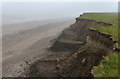
Rapidly eroding coast at Barmston Sands
by Mat Fascione geograph for square TA1660 The misty conditions are due to a cold sea fog known as a sea fret (or Haar). It... (more)
|

|
Eroding cliffs at Barmston Sands
by Mat Fascione geograph for square TA1759 The misty conditions are due to a cold sea fog known as a sea fret (or Haar). It... (more)
Tags:
top:Air, Sky, WeatherX
subject:BeachX
BeachX
Cliff ErosionX
top:CoastalX
type:GeographX
top:Rocks, Scree, CliffsX
Sea Fret
|

|
Skipsea Cliff along the North Sea coast
by Mat Fascione geograph for square TA1855 The misty conditions are due to a sea fret coming off the North Sea.
|

|
Benllech Beach
by Stephen McKay geograph for square SH5282 The weather is warm enough to attract people to sit on the beach but mist swirls... (more)
|

|
Recreation of a 1950s postcard of Saltburn
by Mick Garratt geograph for square NZ6621 Another morning, another haar. And then Ayton cleared. Blue skies. It will be... (more)
|
|
Erosion at Tranmere Cliff
by Mat Fascione geograph for square TA1755 The misty conditions are due to a sea fret coming off the North Sea.
Tags:
top:Air, Sky, WeatherX
subject:CliffX
Cliff ErosionX
top:CoastalX
type:GeographX
top:Rocks, Scree, CliffsX
Sea Fret
|

|
WWII pillbox on the beach at Fraisthorpe Sands
by Mat Fascione geograph for square TA1762 The misty conditions are due to a sea fret (or Haar). It occurs most often on... (more)
Tags:
top:Air, Sky, WeatherX
BeachX
top:CoastalX
top:Defence, MilitaryX
top:Derelict, DisusedX
top:Estuary, MarineX
type:GeographX
subject:PillboxX
Sea Fret
WWII PillboxX
|

|
Anti-tank blocks on Fraisthorpe Sands
by Mat Fascione geograph for square TA1760 The misty conditions are due to a sea fret (or Haar). It occurs most often on... (more)
Tags:
top:Air, Sky, WeatherX
Anti-Tank BlocksX
BeachX
subject:BeachX
top:CoastalX
top:Defence, MilitaryX
top:Derelict, DisusedX
top:Estuary, MarineX
type:GeographX
Sea Fret
|

|
The end of the road
by Mat Fascione geograph for square TA1855 Hornsea Road disappearing over Skipsea Cliff. The misty conditions are due to a... (more)
Tags:
top:Air, Sky, WeatherX
BeachX
Cliff ErosionX
top:CoastalX
type:GeographX
subject:RoadX
RoadX
top:Roads, Road TransportX
top:Rocks, Scree, CliffsX
Sea Fret
|

|
Cliff View from Isle of Wight Pearl
by David Dixon geograph for square SZ4182 Looking west from behind the Isle of Wight Pearl Centre. The last remains of a... (more)
|

|
Bamburgh Beach
by Stephen McKay geograph for square NU1835 In a slightly eerie way the beach disappears into the remains of a sea fret... (more)
|

|
Edge of bank of coastal fret
by Russel Wills geograph for square NU0905 The sea mist was a problem in Alnwick but by Wellhope Knowe the sun had burned... (more)
|

|
Minor road heading west towards Docking
by Christine Johnstone geograph for square TF7942 On the south side of Barrow Common. A sea fret is creating a misty haze.
Tags:
top:Air, Sky, WeatherX
type:GeographX
Minor Rural RoadX
weather:MistyX
Narrow Country LaneX
subject:RoadX
top:Roads, Road TransportX
Roadside TreesX
Sea Fret
Single Track LaneX
Single-Track RoadX
|

|
Sugar beet field, south of Long Plantation
by Christine Johnstone geograph for square TF7942 The plantation is shrouded by a sea fret.
Tags:
top:Farm, Fishery, Market GardeningX
subject:FieldX
type:GeographX
Long PlantationX
weather:MistyX
Sea Fret
crop:Sugar BeetX
Sugar Beet FieldX
|

|
Hedge between two fields, south-east of Field House
by Christine Johnstone geograph for square TF7841 A sea fret has turned the weather misty.
Tags:
top:Air, Sky, WeatherX
top:Farm, Fishery, Market GardeningX
subject:FarmlandX
type:GeographX
Hedgerow and Field EdgeX
Hedgerow Dividing FieldsX
weather:MistyX
Sea Fret
|

|
Sugar beet field, south of Brancaster Field House
by Christine Johnstone geograph for square TF7841 The Field House is about 350 metres away, but barley visible through the sea fret.
Tags:
top:Air, Sky, WeatherX
top:Farm, Fishery, Market GardeningX
subject:FieldX
type:GeographX
weather:MistyX
Sea Fret
crop:Sugar BeetX
Sugar Beet FieldX
|

|
Barley field, north of Sunderland Farm
by Christine Johnstone geograph for square TF7840 A misty afternoon, probably a sea fret.
Tags:
crop:BarleyX
top:Farm, Fishery, Market GardeningX
subject:FieldX
Field of BarleyX
type:GeographX
weather:MistyX
Ripening BarleyX
Sea Fret
|

|
Tree on the minor road to Brancaster Staithe
by Christine Johnstone geograph for square TF7840 275 metres away and looming out of the mist. Only 5 kms from the coast, so this... (more)
Tags:
type:GeographX
Minor Rural RoadX
weather:MistyX
Narrow Country LaneX
top:Roads, Road TransportX
Roadside TreeX
Sea Fret
Single Track LaneX
Single-Track RoadX
subject:TreeX
|

|
Sea fret on Filey beach
by Graham Hogg geograph for square TA1281 |

|
Sea fret, Carsaig Bay
by Mick Garratt geograph for square NM5421 |

|
Sea fret, Carsaig Bay
by Mick Garratt geograph for square NM5421 |

|
The Pilgrim's Way
by Stephen McKay geograph for square NU1242 The tide is encroaching, making the Pilgrim's Way impassable, but has not... (more)
|

|
Bamburgh Castle
by Stephen McKay geograph for square NU1835 The great bulk of Bamburgh Castle overlooks the beach where puffs of mist - the... (more)
|

|
Holy Island Causeway
by Stephen McKay geograph for square NU0842 Cars make their way on to the island for a bank holiday morning visit through a... (more)
|

|
Donna Nook bombing targets in a sea fret
by Steve Fareham for square TA4200 Tags:
top:Air, Sky, WeatherX
top:Defence, MilitaryX
place:Donna NookX
top:Estuary, MarineX
county:LincolnshireX
RAF Donna NookX
Sea Fret
|

|
After the heat of a summer's day 8pm brings a cooling sea fret
by Steve Fareham geograph for square TA3108 Tags:
top:Air, Sky, WeatherX
place:CleethorpesX
top:CoastalX
top:Estuary, MarineX
HaarX
county:LincolnshireX
Sea Fret
|

|
Looking across to Rock from Padstow Quay
by John Myers geograph for square SW9275 A warm, sunny afternoon and a fret rolls into the Camel Estuary
Tags:
top:City, Town CentreX
top:CoastalX
top:Docks, HarboursX
EstuaryX
top:Estuary, MarineX
place:PadstowX
River CamelX
Sea Fret
subject:WeatherX
|

|
Sea fog at Roker, Sunderland
by Malc McDonald geograph for square NZ4059 A foggy Easter Monday morning on the seafront at Roker.
|

|
Fog on the shore at Roker, Sunderland
by Malc McDonald geograph for square NZ4059 Sea fog at Roker, on the morning of Easter Monday 2015.
|

|
Sugar beet field, southern edge of Brancaster civil parish
by Christine Johnstone geograph for square TF7841 60 metres above sea level and about 3 kms from the coast.
Tags:
top:Air, Sky, WeatherX
top:Farm, Fishery, Market GardeningX
subject:FieldX
type:GeographX
weather:MistyX
Sea Fret
crop:Sugar BeetX
Sugar Beet FieldX
|

|
An ebbing tide on a misty day
by Ann Cook geograph for square NX8853 The rocks are covered in wet seaweed while oystercatchers gather at the edge of... (more)
|

|
Deserted by the Haar: A Food Vendor Waits for Customers in the Fog
by Mick Garratt geograph for square NH8089 Tags:
top:Air, Sky, WeatherX
top:Business, Retail, ServicesX
top:CoastalX
Food StoreX
type:GeographX
GorseX
HaarX
Sea Fret
|

|
Farmland north of Sunderland Farm
by Christine Johnstone geograph for square TF7840 On the west side of the minor road to Brancaster Staithe, at the northern edge... (more)
|