Public Tags
Showing latest 50 of 3,604 images tagged with subject:Bay tag.

|
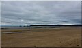
Sunset, Ballyholme Bay
by Rossographer geograph for square J5282 Sunset over Ballyholme Bay, Bangor. Two stand up paddle boarders are returning to shore.
|

|
The Three Cliffs from the Wales Coast Path
by Eirian Evans for square SS5387 Three limestone cliffs jutting out to the sea from the sand dunes. It looks... (more)
Tags:
subject:Bay
top:CoastalX
type:Cross GridX
DunesX
top:Estuary, MarineX
top:Geological InterestX
top:PathsX
top:Rocks, Scree, CliffsX
top:Sport, LeisureX
|

|
Lift and stairs down to Marsden Bay and Grotto
by Mat Fascione geograph for square NZ3964 On the left is Marsden Rock.
|

|
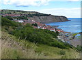
Robin Hood's Bay
by James Richardson-Lewis for square NZ9504 An aerial view from near Middlewood Farm
Tags:
type:AerialX
Aerial PhotographX
subject:Bay
top:CoastalX
type:Cross GridX
top:Farm, Fishery, Market GardeningX
top:GrasslandX
top:Housing, DwellingsX
subject:LandscapeX
place:North SeaX
place:North YorkshireX
Roadside TreesX
place:Robin Hoods BayX
top:Rocks, Scree, CliffsX
top:Village, Rural SettlementX
near:WhitbyX
top:Woodland, ForestX
|

|
Camel Island at the northern end of Marsden Bay
by Mat Fascione geograph for square NZ3965 |

|
Nigg Bay Sunset
by valenta geograph for square NH7773 Although the sun had just about set, it is just possible to make out the wooden... (more)
|

|
Robin Hood's Bay
by PAUL FARMER geograph for square NZ9504 |

|
Wemyss Bay
by Thomas Nugent geograph for square NS1969 The bay which gives the village its name.
|

|
Wemyss Bay
by Thomas Nugent geograph for square NS1969 The bay which gives the village its name. The red sandstone house on the right... (more)
|

|
The 'Incentive' off Bangor
by Rossographer for square J4982 The 'Incentive' B.89, lifting and laying creels in Bangor Bay. See a... (more)
Tags:
place:BangorX
Bangor BayX
place:Bangor BayX
Bay
subject:Bay
subject:BoatX
top:City, Town CentreX
top:CoastalX
CreelsX
top:Docks, HarboursX
type:ExtraX
Fishing BoatX
IncentiveX
Inshore Fishing BoatsX
|

|
The 'Incentive' off Bangor
by Rossographer for square J4982 The 'Incentive' B.89, lifting and laying creels in Bangor Bay. See a... (more)
Tags:
place:BangorX
Bangor BayX
place:Bangor BayX
subject:Bay
Bay
subject:BoatX
top:City, Town CentreX
top:CoastalX
CreelsX
top:Docks, HarboursX
type:ExtraX
Fishing BoatX
IncentiveX
Inshore Fishing BoatsX
|

|
View over Lynmouth Bay
by Lauren for square SS7249 Tags:
subject:Bay
Bay
CoastX
subject:CoastX
top:CoastalX
type:Cross GridX
top:Estuary, MarineX
place:ExmoorX
ExmoorX
national park:ExmoorX
Exmoor National ParkX
LynmouthX
place:LynmouthX
place:Lynmouth BayX
Lynton & Lynmouth Cliff RailwayX
railway:Lynton and Lynmouth Cliff RailwayX
SeaX
subject:SeaX
subject:ViewX
ViewX
|

|
Swansea Bay
by Lauren geograph for square SS6287 |

|
Swansea Bay
by Lauren geograph for square SS6287 |

|
Swansea Bay
by Lauren geograph for square SS6290 |
|
Swansea Bay
by Lauren geograph for square SS6290 |

|
Cawsand Bay with boats from The Cleave, Kingsand
by Rob Farrow for square SX4350 Taken from the balcony of a house in The Cleave, Kingsand, looking out over... (more)
|

|
Robin Hood�s Bay
by Mick Garratt geograph for square NZ9502 Early morning from above Stoupe Brow. A strange name, Robin Hood�s Bay, its... (more)
|

|
Nigg Bay Nature Reserve
by valenta geograph for square NH7972 Nigg Bay, just off the B9175 and the end of the Bishop's Walk
Tags:
subject:Bay
top:CoastalX
top:Estuary, MarineX
type:GeographX
subject:Nature ReserveX
bay:Nigg BayX
Sands at Low TideX
top:Sport, LeisureX
|

|
Frenchman's Bay at South Shields
by Mat Fascione geograph for square NZ3966 |

|
Marsden Bay at South Shields
by Mat Fascione geograph for square NZ4064 In the centre of the shot is Marsden Rock.
|

|
Munlochy Bay
by valenta for square NH6553 View over Munlochy Bay to the Norboard OSB factory at Morayhill, recently... (more)
Tags:
subject:Bay
top:Business, Retail, ServicesX
top:CoastalX
type:Cross GridX
top:Estuary, MarineX
bay:Munlochy BayX
The Black IsleX
subject:ViewX
|

|
Nigg Bay
by valenta geograph for square NH7772 Looking inland over a combination of mud, shingle, and sand at Nigg Bay
|

|
Nigg Bay
by valenta geograph for square NH7773 Low tide at sunset looking over to the Nigg fabrication yard.
|

|
Foryd Bay
by Eirian Evans for square SH4459 Foryd Bay is a tidal bay at the south-western end of the Menai Straits, about... (more)
|

|
Foryd Bay
by Eirian Evans geograph for square SH4558 Foryd Bay is a tidal bay at the south-western end of the Menai Straits, about... (more)
Tags:
subject:Bay
top:CoastalX
top:Estuary, MarineX
place:Foryd BayX
top:Rivers, Streams, DrainageX
Salt MarshX
SSSIX
|

|
Foryd Bay
by Eirian Evans geograph for square SH4559 Foryd Bay is a tidal bay at the south-western end of the Menai Straits, about... (more)
Tags:
subject:Bay
top:CoastalX
CoastlineX
top:Estuary, MarineX
Local Nature ReserveX
top:Rivers, Streams, DrainageX
SSSIX
|

|
Foryd Bay
by Eirian Evans geograph for square SH4559 Foryd Bay is a tidal bay at the south-western end of the Menai Straits, about... (more)
Tags:
subject:Bay
top:CoastalX
top:Estuary, MarineX
top:Flat LandscapesX
place:Foryd BayX
Local Nature ReserveX
SSSIX
|

|
Selwicks Bay, Flamborough Head
by Scott Robinson geograph for square TA2570 The view back along the coastline across Selwicks Bay to Stottle Bank Nook in... (more)
Tags:
top:Air, Sky, WeatherX
subject:Bay
Bay
ChalkX
subject:CliffX
subject:CoastX
top:CoastalX
CoastlineX
East YorkshireX
country:EnglandX
top:Estuary, MarineX
place:FlamboroughX
place:Flamborough HeadX
ldp:Headland WayX
place:North SeaX
top:Rocks, Scree, CliffsX
subject:SeasideX
ViewX
subject:ViewX
WaterX
place:YorkshireX
|

|
Bay in front of Traigh Halum, Coll
by eswales geograph for square NM1153 Category: Bay View northwestwards from the eastern end of Traigh Halum across the bay which... (more)
|

|
Sorisdale Bay, Coll
by eswales geograph for square NM2763 Category: Bay The bay at the end of the road in the north east of Coll, viewed from high... (more)
|

|
Loch Ness - The lower slopes of Balnacraig across Urquhart Bay
by Chris Gorringe for square NH5230 Tags:
BalnacraigX
subject:Bay
type:Cross GridX
top:GrasslandX
subject:HillX
top:Lakes, Wetland, BogX
loch:Loch NessX
subject:SlopeX
bay:Urquhart BayX
|

|
Morecambe Bay looking north-east at Bare
by Christopher Hilton geograph for square SD4464 |

|
Lee Bay
by Lauren geograph for square SS6949 Tags:
Bay
subject:Bay
CoastX
subject:CoastX
top:CoastalX
top:Estuary, MarineX
place:ExmoorX
national park:ExmoorX
ExmoorX
Exmoor National ParkX
type:GeographX
place:Lee BayX
subject:SeaX
SeaX
long distance path:South West Coast PathX
place:South West Coast PathX
South West Coast PathX
path:South West Coast PathX
|

|
Sunset over Holes Bay, Poole
by Malc McDonald geograph for square SZ0090 Holes Bay is a smaller bay off Poole Harbour. This image was taken at sunset on... (more)
Tags:
Bay
subject:Bay
near:BournemouthX
Coastal SunsetX
top:Estuary, MarineX
type:GeographX
place:PooleX
time:SunsetX
SunsetX
Sunset LightX
Sunset Over the SeaX
Sunset ViewX
Winter SunsetX
|

|
Beach and dunes at Largo Bay
by Mat Fascione geograph for square NO4402 Largo Bay is on the northern shore of the Firth of Forth, on the coast of Fife.... (more)
|

|
Cocklemill Burn flowing into Largo Bay
by Mat Fascione geograph for square NO4500 Largo Bay is on the northern shore of the Firth of Forth, on the coast of Fife.... (more)
|

|
Largo Bay at the Dumbarnie Links
by Mat Fascione geograph for square NO4302 Largo Bay is on the northern shore of the Firth of Forth, on the coast of Fife.... (more)
|

|
Lyme Bay
by Marika Reinholds geograph for square SY3391 A view of Lyme Bay taken from just above The Oyster and Fish House, off Cobb... (more)
Tags:
top:Air, Sky, WeatherX
Bay
subject:Bay
top:CoastalX
top:Estuary, MarineX
type:GeographX
bay:Lyme BayX
Lyme RegisX
place:Lyme RegisX
top:Suburb, Urban FringeX
|

|
Sunset over Ballyholme Bay
by Rossographer geograph for square J5283 December sunset over Ballyholme Bay in Bangor from Ballymacorrmick Point. The... (more)
Tags:
top:Air, Sky, WeatherX
Ballyholme BayX
place:Ballyholme BayX
place:BangorX
BangorX
Bangor (Co Down)X
subject:Bay
Bay
top:CoastalX
DecemberX
type:GeographX
Sunset Over the SeaX
|

|
Ballyholme Bay at night
by Rossographer for square J5182 A view across Ballyholme Bay from the Seacliff Road. Lights from Ballyholme... (more)
Tags:
BallyholmeX
Ballyholme BayX
place:Ballyholme BayX
place:BangorX
Bangor (Co Down)X
subject:Bay
top:City, Town CentreX
top:CoastalX
top:Estuary, MarineX
type:ExtraX
Light ReflectionX
LightsX
time:NightX
at:NightX
NightX
taken:NightX
Night PhotographyX
Night PictureX
Night SceneX
Night TimeX
Night ViewX
Reflected LightX
Street LightingX
Street LightsX
View Across BayX
|
|
Robin Hood's Bay viewed from the Cleveland Way
by Mat Fascione geograph for square NZ9504 Tags:
Bay
subject:Bay
long distance path:Cleveland WayX
top:CoastalX
long distance path:England Coast PathX
type:GeographX
top:Rocks, Scree, CliffsX
VillageX
top:Village, Rural SettlementX
|

|
Munlochy Bay at low tide
by valenta geograph for square NH6753 Looking over the field near Bay Farm towards Drumderfit Hill on the far side of the bay
Tags:
subject:Bay
top:CoastalX
hill:Drumderfit HillX
top:Estuary, MarineX
type:GeographX
top:GrasslandX
at:Low TideX
bay:Munlochy BayX
The Black IsleX
|

|
High tide at Budle Bay
by Mat Fascione geograph for square NU1434 Budle Bay is a 1 mile (1.6 km) wide bay on the North Sea coast of... (more)
|

|
Budle Bay at the Lindisfarne National Nature Reserve
by Mat Fascione geograph for square NU1434 Budle Bay is a 1 mile (1.6 km) wide bay on the North Sea coast of... (more)
|

|
Brunton Burn flowing into Beadnell Bay
by Mat Fascione geograph for square NU2227 |

|
Marsden Bay at South Shields
by Mat Fascione geograph for square NZ3965 |

|
Marsden Bay at South Shields
by Mat Fascione geograph for square NZ3965 |

|
Collywell Bay
by Andrew Curtis geograph for square NZ3376 The detached sea-stack called Charley�s Garden NZ3376 : Charley's Garden, Collywell Bay lies just off... (more)
Tags:
subject:Bay
top:CoastalX
top:Estuary, MarineX
type:GeographX
top:Geological InterestX
top:PathsX
top:Rocks, Scree, CliffsX
top:Village, Rural SettlementX
|

|
Aerial view of Bay Farm and Munlochy Bay
by Julian Paren for square NH6753 Low tide in Munlochy Bay with mostly mud exposed. Fields and woods surround Bay... (more)
|