Public Tags
Tag: Ledge
Showing images tagged with Ledge tag.

|
Kimmeridge: looking over the Ledges
by Chris Downer geograph for square SY9079 An overview of the western half of Kimmeridge Bay, with the Kimmeridge Ledges... (more)
|

|
Kimmeridge: waves splash at Washing Ledge
by Chris Downer for square SY9079 The high tide is just starting to recede, so the ledges in Kimmeridge Bay are... (more)
|

|
Kimmeridge: Washing Ledge
by Chris Downer geograph for square SY9079 Two people take a wander along the most prominent of the limestone ledges which... (more)
|

|
Dancing Ledge
by Becky Williamson geograph for square SY9976 So named because, in storms, the waves dash against the natural ledge here in a... (more)
|

|
Kimmeridge: birds on a ledge
by Chris Downer geograph for square SY9079 Birds stand along one of the limestone ledges jutting out into Kimmeridge Bay.... (more)
|

|
Ledge route to The Cobbler summit
by Callum Black geograph for square NN2505 Looking straight down from the summit of The Cobbler on to the ledge that must... (more)
|

|
Ledges near Hardman Rock
by J W Parker for square SZ4082 Walking along The Undercliff from Brook Chine at low tide it was possible to... (more)
|

|
Overhanging ledges on the Cliffs of Moher
by Oliver Dixon geograph for square R0492 To the north of O'Brien's Tower, the horizontal strata form... (more)
|

|
Overhanging ledges on the Cliffs of Moher
by Oliver Dixon geograph for square R0492 To the north of O'Brien's Tower, the horizontal strata form... (more)
|

|
Kimmeridge: between two ledges
by Chris Downer geograph for square SY9079 Looking out across the bay between SY9079 : Kimmeridge: Washing Ledge and the next ledge along to the west.
|

|
Kimmeridge: a dolomite stripe runs up the cliff
by Chris Downer geograph for square SY9079 With SY9079 : Kimmeridge: Washing Ledge behind us, here we see the dolomite band of cliff which is... (more)
|

|
Dancing Ledge
by David Martin geograph for square SY9976 Combination of natural rock ledge with worked out quarry above. This is the... (more)
|

|
Osmington Mills: canoeists negotiate Hannah�s Ledge
by Chris Downer for square SY7381 These canoeists set off from Ringstead, a mile or so east, and kept more or less... (more)
|

|
Portland, ledges
by Mike Faherty geograph for square SY6868 Category: Ledges Perhaps created by a former quarry - see the large blocks of loose stone.
Tags:
top:CoastalX
top:Derelict, DisusedX
top:Estuary, MarineX
category:LedgesX
top:Quarrying, MiningX
|

|
A ledge at Smaithwaite Banks
by Walter Baxter geograph for square NY3019 This spot is popular with low level flying photographers when RAF jets fly... (more)
|

|
Above Mill Bay
by Graham Horn geograph for square SW3523 The coastal path follows a narrowish ledge a little way above Mill Bay. It is... (more)
|

|
Dancing Ledge, looking west from the coast path
by David Martin geograph for square SY9976 Tags:
subject:CliffX
top:CoastalX
top:Estuary, MarineX
type:GeographX
top:Geological InterestX
Ledge
top:Rocks, Scree, CliffsX
|

|
View eastward above Dancing Ledge
by David Martin geograph for square SY9976 From the coast path.
Tags:
subject:CliffX
top:CoastalX
top:Estuary, MarineX
type:GeographX
top:Geological InterestX
Ledge
top:Rocks, Scree, CliffsX
|

|
Winspit, cove & ledge
by Mike Faherty geograph for square SY9776 Looking across the opening at Winspit Bottom towards West Man.
Tags:
top:CoastalX
subject:CoveX
top:Estuary, MarineX
type:GeographX
top:Geological InterestX
Jurassic CoastX
Ledge
World Heritage SiteX
|

|
Woodland path above Triscombe
by Bill Boaden geograph for square ST1535 The path traverses the hillside on a ledge which has been hewed out. It is quite... (more)
|

|
Durlston, ledges
by Mike Faherty geograph for square SZ0376 At Anvil Point.
|

|
Ogmore-by-Sea, cliff and ledges
by Mike Faherty geograph for square SS8674 |

|
Cowslips, Bishop's Walk
by Derek Harper for square SX9364 Still flourishing, on ledges and a shelf in the limestone cliff face beside the... (more)
Tags:
type:Close LookX
top:CoastalX
plant:CowslipsX
Ledge
Primula VerisX
top:Rocks, Scree, CliffsX
long distance path:South West Coast PathX
top:Wild Animals, Plants and MushroomsX
|

|
Kittiwake Panel on Baltic Centre Viewing Platform
by David Dixon for square NZ2563 Each year, the Newcastle Gateshead quayside becomes home to some 700 pairs of... (more)
|

|
Kittiwakes Roosting on the Baltic Flour Mill
by David Dixon for square NZ2563 Each year, the Newcastle Gateshead quayside becomes home to some 700 pairs of... (more)
Tags:
KittiwakeX
Ledge
camera:Panasonic DMC-G7X
RiverX
river:River TyneX
top:Rivers, Streams, DrainageX
SeabirdsX
SeagullsX
top:Wild Animals, Plants and MushroomsX
|

|
Dalby, Niarbyl
by Mike Faherty geograph for square SC2177 "The tail", a ledge protruding into the sea.... (more)
|

|
Pair of cormorants on the cliff face
by Pauline E for square TA1182 Phalacrocorax carbo - A wide ledge provides a perch for this pair of waterbirds.
Tags:
Cliffside PerchesX
top:CoastalX
birds:CormorantsX
Ledge
top:Wild Animals, Plants and MushroomsX
|

|
Birds on the Cliffs of Moher
by Oliver Dixon for square R0492 At 214 metres above sea level, the Cliffs of Moher are a popular visitor... (more)
|

|
Kimmeridge: low view over Washing Ledge
by Chris Downer geograph for square SY9079 The ragged limestone outline of SY9079 : Kimmeridge: Washing Ledge as it leaves the shore and projects... (more)
|

|
Bill of Portland: a gull and a breaking wave
by Chris Downer for square SY6768 A seagull is seen mid-flight just high enough to avoid being affected by a wave... (more)
|

|
Into the Round Hole
by Derek Harper geograph for square SW8576 A wider view of the 40 metre deep blowhole shown in SW8576 : Into the Round Hole, the rocks a... (more)
|
|
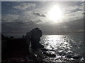
Bill of Portland: Pulpit Rock is silhouetted
by Chris Downer for square SY6768 After a cloudless morning, by the time I reached the Bill it had clouded over... (more)
|

|
Cowslips, Bishop's Walk
by Derek Harper for square SX9364 Category: Wild flowers Primula veris near the western end of the walk, not far from Anstey's Cove Road.
Tags:
CliffX
top:CoastalX
plant:CowslipsX
Ledge
Primula VerisX
top:Rocks, Scree, CliffsX
long distance path:South West Coast PathX
top:Wild Animals, Plants and MushroomsX
|