Public Tags
Tag: RSPB
Showing latest 50 of 173 images tagged with RSPB tag but excluding images with Reserve tag.

|
Wood sculpture, RSPB Minsmere
by Roger Jones for square TM4766 An educational sculpture listing points of interest for visitors at RSPB Minsmere.
|

|
Bracken growing in broken tree branch, RSPB Minsmere
by Roger Jones for square TM4667 The woodland is part of the RSPB Minsmere nature reserve.
|

|
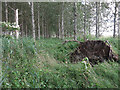
Path in woodland near Westleton Walks, RSPB Minsmere
by Roger Jones geograph for square TM4667 The woodland is part of the RSPB Minsmere nature reserve.
|

|
Road from RSPB Minsmere to Eastbridge
by Roger Jones geograph for square TM4566 |

|
Road from RSPB Minsmere to Eastbridge
by Roger Jones geograph for square TM4567 |

|
Island Mere Hide, RSPB Minsmere
by Roger Jones geograph for square TM4666 |

|
Oak tree in clearing at RSPB Minsmere
by Roger Jones geograph for square TM4667 |
|
RSPB Seasbird Research Station at Bempton
by David Dixon geograph for square TA1974 The Seabird Research Station at Bempton Cliffs is a dedicated facility operated... (more)
|

|
RSPB reserve woodland
by Richard Croft geograph for square TL1947 Steps and path through woodland at The Lodge RSPB reserve
|

|
In the frame
by Richard Croft for square TL1948 There are several of these frames at The Lodge RSPB reserve, this one framing... (more)
|

|
Sandy Warren
by Richard Croft geograph for square TL1847 View towards Meadow Hide at The Lodge RSPB reserve
|

|
Swiss Cottage lodge
by Richard Croft geograph for square TL1948 Grade II listed yellow brick lodge in a Swiss Chalet style, now the visitor... (more)
|

|
Sandy Warren
by Richard Croft geograph for square TL1948 Scrubland view at The Lodge RSPB reserve
|

|
Garden terrace
by Richard Croft geograph for square TL1847 Terrace and garden front of the Neo Elizabethan mansion by Henry Clutton 1869-70... (more)
Tags:
top:Country EstatesX
Country HouseX
Grade II ListedX
top:Historic Sites and ArtefactsX
MansionX
top:PathsX
RSPB
|

|
Woodland path
by Richard Croft geograph for square TL1948 Path through deciduous woodland at The Lodge RSPB reserve
|

|
The Lodge RSPB reserve
by Richard Croft geograph for square TL1948 Path at The Lodge reserve
|

|
The Lodge
by Richard Croft geograph for square TL1847 Garden front of the Neo Elizabethan mansion by Henry Clutton 1869-70 for the... (more)
|

|
The Lodge
by Richard Croft geograph for square TL1847 Neo Elizabethan mansion by Henry Clutton 1869-70 for the first Viscount Peel... (more)
|

|
The Lodge
by Richard Croft geograph for square TL1847 Neo Elizabethan mansion by Henry Clutton 1869-70 for the first Viscount Peel... (more)
|

|
View of Rockland Broad from bird hide
by Roger Jones geograph for square TG3304 This is the view from the RSPB hide at Rockland Broad, near the River Yare. See... (more)
|

|
Memorial Garden
by Richard Croft geograph for square TL1847 Memorial Garden at The Lodge
|

|
Sandy Warren
by Richard Croft geograph for square TL1948 Rabbits on Sandy Warren
|

|
Car park and toilets RSPB Titchwell
by Steve Fareham geograph for square TF7543 Pay and display car park free to RSPB members.
|

|
Entrance to RSPB's Hope Farm, Knapwell
by Martin Tester geograph for square TL3362 The RSPB purchased Hope Farm in 2000 in an attempt to investigate how to reverse... (more)
Tags:
subject:FarmX
top:Farm, Fishery, Market GardeningX
type:GeographX
at:KnapwellX
top:Roads, Road TransportX
RSPB
top:Village, Rural SettlementX
|

|
RSPB Scotland - Let's give wildlife a home
by M J Richardson geograph for square NS5666 'An amazing weekend of fun and fungi' at Kelvingrove Art Gallery and... (more)
Tags:
top:City, Town CentreX
top:Educational SitesX
subject:EventX
type:GeographX
place:GlasgowX
Kelvingrove Art Gallery and MuseumX
top:LowlandsX
top:People, EventsX
top:Public Buildings and SpacesX
RSPB
|

|
Old Moor RSPB site's Bittern viewing point
by Steve Fareham geograph for square SE4202 Bitterns have bred for the first time in the Dearne Valley and the RSPB has... (more)
Tags:
near:BarnsleyX
BitternX
Dearne ValleyX
top:LowlandsX
place:Old MoorX
Royal Society for the Protection of Birds (RSPB)X
RSPB
top:Sport, LeisureX
|

|
RSPB building at Lake Vyrnwy
by TCExplorer geograph for square SJ0119 I'm not sure what the building is used for but it says RSPB on the door.
|

|
Coll - Totronald - Footbridge to RSPB viewing area
by Rob Farrow geograph for square NM1656 This little footbridge allows access over a ditch (which in wetter weather may... (more)
|

|
Coll - Totronald - RSPB Nature Reserve centre
by Rob Farrow geograph for square NM1656 This is the RSPB HQ and Information Centre for the Coll Nature Reserve.
|

|
RSPB stand on Worcester High Street
by Philip Halling geograph for square SO8554 A RSPB stand in front of the Guildhall on Worcester's High Street.
|

|
Road to Grapnells farm & Wallasea Island Wild Coast Project
by Roger Jones geograph for square TQ9494 Wallasea Island Wild Coast Project, run by the RSPB, is a conservation and... (more)
Tags:
county:EssexX
top:Farm, Fishery, Market GardeningX
top:Roads, Road TransportX
RSPB
place:Wallasea IslandX
Wallasea Island Wild Coast ProjectX
|

|
Grapnells farm and Wallasea Island Wild Coast project Site office
by Roger Jones geograph for square TQ9494 Wallasea Island Wild Coast Project, run by the RSPB, is a conservation and... (more)
Tags:
top:Construction, DevelopmentX
county:EssexX
top:Farm, Fishery, Market GardeningX
RSPB
place:Wallasea IslandX
Wallasea Island Wild Coast ProjectX
|

|
The Wash, beach at Snettisham
by Steve Fareham geograph for square TF6431 RSPB site.
Tags:
top:Air, Sky, WeatherX
top:CoastalX
top:Estuary, MarineX
county:NorfolkX
NorfolkX
Royal Society for the Protection of Birds (RSPB)X
RSPB
The WashX
|

|
The access trail to the RSPB site Snettisham
by Steve Fareham geograph for square TF6431 The earth bank is between 2 of the pits created by aggregate extraction in World war 2.
|

|
Chalets, caravans, huts etc across the lake at Snettisham
by Steve Fareham geograph for square TF6432 From the access trail to the beach at RSPB Snettisham.
|

|
Shepherd's Port fishing ponds, Snettisham Norfolk
by Steve Fareham geograph for square TF6532 Near the car park for the RSPB site.
|

|
Sky and salt marsh RSPB Titchwell
by Steve Fareham geograph for square TF7544 |

|
Footpath to the beach RSPB Titchwell
by Steve Fareham geograph for square TF7443 A public footpath on the reserve.
|

|
Welcome to Wombwell Ings
by Dave Pickersgill geograph for square SE4103 Sign welcoming walkers to the RSPB site at Wombwell Ings, South Yorkshire.
|

|
Balranald Visitor Centre
by Colin Smith geograph for square NF7070 RSPB Visitor Centre by Traigh nam Faoghailean on the west coast of North Uist.... (more)
|

|
Lady Lane
by Tim Marchant geograph for square TM0543 Lady Lane (A1071) by the entrance to Wolves Wood RSPB Reserve.... (more)
|

|
Sandy Warren, RSPB headquarters and Nature Reaserve
by nick macneill geograph for square TL1847 Category: Rock feature There are basically two walks around the RSPB reserve, one through gentle... (more)
|

|
Christmas Robin
by Dave Pickersgill for square SE4527 A Robin at RSPB Fairburn Ings on Christmas Eve.
Tags:
type:Close LookX
top:Educational SitesX
top:Lakes, Wetland, BogX
top:LowlandsX
bird:RobinX
RSPB
place:RSPB Fairburn IngsX
top:Sport, LeisureX
|

|
Coots at Newport Wetlands
by Robin Drayton for square ST3383 An adult coot with a chick on the scrape by the RSPB visitor centre.
The... (more)
Tags:
type:Close LookX
bird:CootX
top:Lakes, Wetland, BogX
Natural Resources WalesX
place:NewportX
Newport WetlandsX
RSPB
top:Wild Animals, Plants and MushroomsX
|

|
Sky and salt marsh RSPB Titchwell
by Steve Fareham for square TF7443 Tags:
top:Air, Sky, WeatherX
top:Business, Retail, ServicesX
top:CoastalX
top:Estuary, MarineX
NorfolkX
place:NorfolkX
county:NorfolkX
Royal Society for the Protection of Birds (RSPB)X
RSPB
top:Sport, LeisureX
|

|
A tree full of kites
by M J Richardson geograph for square NX6865 At Bellymack Hill Farm, a good place to see red kites, which are doing well... (more)
Tags:
place:Bellymack HillX
BirdsX
top:Farm, Fishery, Market GardeningX
GallowayX
top:GrasslandX
KitesX
top:LowlandsX
RSPB
top:Wild Animals, Plants and MushroomsX
top:Woodland, ForestX
|

|
Rain is still needed at RSPB Edderthorpe Flash
by Steve Fareham geograph for square SE4107 Tags:
top:Lakes, Wetland, BogX
RSPB
|

|
Low water levels RSPB Edderthorpe
by Steve Fareham geograph for square SE4107 Looking towards Darfield.
Tags:
top:Lakes, Wetland, BogX
RSPB
|

|
The RSPB garden at Flatford
by David Smith geograph for square TM0733 The garden is a showcase for wildlife friendly gardening, not simply for birds
|
|
Poplar plantation, Lakenheath RSPB
by Hugh Venables geograph for square TL7085 Golden Orioles are maintaining a toehold in these non-native plantations, but... (more)
|