Public Tags
Tag: Flooded·Footpath
Showing images tagged with Flooded Footpath tag.

|
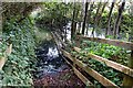
Flooded riverside footpath, Usk
by Jaggery geograph for square SO3700 For most of the time, this footpath on the east bank of the River Usk gives a... (more)
|

|
Flooded Footpath
by David Dixon geograph for square SJ7493 Floodwater has made this path, off Carrington Lane, impassable. Although frozen,... (more)
|

|
The End of The Twist at College Lake
by Chris Reynolds geograph for square SP9314 Before the Lake rose as far as it did this path ran along at the base of the... (more)
Tags:
top:Educational SitesX
subject:FloodX
Flooded Footpath
FootpathX
top:PathsX
top:Rivers, Streams, DrainageX
top:Sport, LeisureX
|

|
Flooded Footpath near Holmsley Inclosure
by Mike Smith geograph for square SU2200 This footpath in the New Forest is completely flooded by nearby streams.... (more)
|

|
Path by Hilda's Wood Impassable with Floodwater
by Chris Heaton geograph for square TL5448 By Hilda's Wood, the River Granta has burst its banks and flooded the... (more)
|

|
Flooded footpath to South Cerney
by Vieve Forward geograph for square SU0396 Despite recent hot weather, this public footpath was under a few inches of water... (more)
|

|
Flooded Gate onto the Common
by Des Blenkinsopp geograph for square SU6491 The Ewelme Brook usually has its source a bit further down the valley from here... (more)
|

|
Flooded path by the Animal Sanctuary
by Des Blenkinsopp geograph for square SU3977 The Shefford Stream, an ephemeral river which appears in this valley only when... (more)
|

|
Gates and flood, Shute Footpath 18
by Derek Harper geograph for square SY2496 The footpath crosses the very Watery Lane here, shown in SY2496 : Flooded green lane, Lexhayne], so... (more)
|

|
Overflowing pond
by Ian Calderwood geograph for square SK5856 At the end of a wet February, this pond was flooding on to the neighbouring footpath.
Tags:
Flooded Footpath
Flooded PathX
type:GeographX
top:Lakes, Wetland, BogX
Overflowing WaterX
top:PathsX
subject:PondX
|

|
Cone on a Wet Path
by Des Blenkinsopp geograph for square SU5788 These fields beside the Mill Brook are very prone to flooding and get submerged... (more)
|

|
Under a railway bridge, west of Haltwhistle Burn
by Christine Johnstone geograph for square NY7163 Two days after Storm Dennis and ten days after Storm Ciara, this public footpath... (more)
Tags:
Flooded Footpath
path:FootpathX
type:GeographX
place:HaltwhistleX
Public FootpathX
bridge:Railway Over TrackX
top:RailwaysX
top:Roads, Road TransportX
|

|
Flooded Footpath in Lathkill Dale
by Chris Heaton geograph for square SK1965 The path that follows the River Lathkill, in a deep and steep sided valley is... (more)
|

|
Flooded footpath, Levens Bridge
by Karl and Ali geograph for square SD4985 The swollen River Kent has overflowed the public footpath which runs up the... (more)
Tags:
top:Air, Sky, WeatherX
top:Country EstatesX
Flooded Footpath
river:KentX
Levens ParkX
top:LowlandsX
top:PathsX
Public FootpathX
top:Rivers, Streams, DrainageX
Swollen RiverX
|

|
This way for a damp walk
by David Smith geograph for square SX9588 The sign points to a footpath which follows the fence under the M5 viaduct.... (more)
Tags:
Flooded Footpath
Footpath SignX
top:Lakes, Wetland, BogX
road:M5X
top:PathsX
top:Roads, Road TransportX
ViaductX
|

|
Flooded Forestry Track
by Nigel Mykura geograph for square SY8792 This flooded track through the woods was only passable by clambering from one... (more)
Tags:
ConiferX
Conifer PlantationX
Conifer TreesX
ConiferousX
Coniferous ForestX
Coniferous TreesX
Cut LogsX
Cut TimberX
Flooded Bridle PathX
Flooded Footpath
Flooded Forestry TrackX
ForestryX
Forestry Access RoadX
Forestry ActivityX
Forestry OperationsX
Forestry PlantationsX
Forestry RoadsX
Forestry TrackX
Forestry WorkX
top:Heath, ScrubX
Sandy TrackX
top:Woodland, ForestX
|

|
Flooded footpath
by Peter Holmes geograph for square SU7506 Public footpath 240 to Mill Lane.
|

|
Aww.... Spoilsports
by Des Blenkinsopp geograph for square SU7874 Flooded footpath, without motorcycles, near Whistley Bridge.
Tags:
Flooded Footpath
top:PathsX
|

|
A flooded footpath
by Steve Daniels geograph for square SU7772 Tags:
Flooded Footpath
top:PathsX
|

|
The King's Arms
by David Dixon for square SE6051 The King's Arms, suffering as the level of the Ouse rises to flood the... (more)
|

|
River Ouse In Flood
by David Dixon geograph for square SE6051 After heavy snowfall during the first three months of 1979, a rapid thaw set in... (more)
|
|
A Truly Undesirable Path
by Des Blenkinsopp geograph for square TQ0167 In a picture from some time ago TQ0167 : Footpath by the motorway showing a clear and newly fenced... (more)
|

|
Flooded footpath to the River Thames
by Steve Daniels geograph for square SP5202 |

|
Flooded Footpath
by Des Blenkinsopp geograph for square SK1715 Feb. 2014, and like many other parts of the country this riverside land is under water.
|

|
Footbridge at Keynston Mill
by Nigel Mykura geograph for square ST9103 The river was very high and had started to cover the structure of the bridge.... (more)
|
|
Flooded footpath in Bysing Wood
by pam fray geograph for square TQ9961 Near Bysing Wood Road.
|

|
Flooded footpath near Marlow
by Bill Boaden geograph for square SU8485 Possibly passable in wellies, but not in anything less. The path crosses... (more)
Tags:
Flooded Footpath
type:GeographX
top:Heath, ScrubX
top:Lakes, Wetland, BogX
top:LowlandsX
top:PathsX
|

|
Flooded path to Aqualate bird hide
by Jonathan Hutchins geograph for square SJ7820 Wellies were essential as the water was almost a foot deep over the duckboards.
Tags:
Aqualate ParkX
top:Country EstatesX
DuckboardsX
subject:FloodX
Flooded Footpath
top:LowlandsX
top:PathsX
|

|
Flooded path to Aqualate bird hide
by Jonathan Hutchins geograph for square SJ7820 Wellies were essential as the water was almost a foot deep over the duckboards.
Tags:
Aqualate ParkX
Bird HideX
Birdwatching HideX
top:Country EstatesX
DuckboardsX
subject:FloodX
Flooded Footpath
top:LowlandsX
top:PathsX
top:Sport, LeisureX
|

|
Underwater Walkway 2
by Des Blenkinsopp geograph for square SU7671 The other bank of the flooded River Loddon from SU7671 : Underwater Walkway
|

|
A flooded High Weald Landscape Trail
by Marathon geograph for square TQ5236 The High Weald Landscape Trail here passes under the Uckfield Line. The water... (more)
Tags:
top:Air, Sky, WeatherX
Flooded Footpath
type:GeographX
long distance path:High Weald Landscape TrailX
top:PathsX
top:RailwaysX
|

|
Green Chain Under Water
by Des Blenkinsopp geograph for square TQ4171 After a long wet spell the small streams that run downhill from Elmstead Woods... (more)
Tags:
Flooded Footpath
type:GeographX
long distance path:Green Chain WalkX
top:PathsX
top:Rivers, Streams, DrainageX
|

|
The path to Manesty!
by David Purchase geograph for square NY2618 Not many walkers will be using this path, which heads straight for the... (more)
|

|
Footpath Warning Sign
by John Myers for square TQ7197 For once the signage was not OTT! The footpath was a swamp. On a warmer day... (more)
Tags:
bucket:CloseupX
Flooded Footpath
top:LowlandsX
top:PathsX
Warning NoticeX
top:Woodland, ForestX
|

|
Flood on the track to High Ickenthwaite
by Tom Richardson geograph for square SD3188 The bridleway from Oxen Park joins this track by the wall at the top of the picture
|

|
Doxey Marshes
by Derek Harper geograph for square SJ9024 From the same spot as SJ9024 : Doxey Marshes, looking along Stafford footpath 27 (right)... (more)
|

|
Soggy Path at Emery Down
by Des Blenkinsopp geograph for square SU2808 To be fair, the map does show the path and the stream in the same place.
What... (more)
|

|
Path under Water
by Des Blenkinsopp geograph for square SU6375 What is shown on the map as a drainage ditch is now carrying a substantial flow... (more)
|