Shared description
A4053 Coventry Ring Road
Link
Link
Link
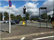
The Coventry ring road, designated as the A4053, is a 2.25-mile (3.62 km) ring road in Coventry, England, which forms a complete dual-carriageway loop around the city centre. The road encompasses the old and new Coventry Cathedrals, the city's shopping areas and much of Coventry University. With the exception of one roundabout at junction 1, the ring road's nine junctions are grade separated and closely spaced, with weaving sections between them, some as short as 300 feet (90 m), giving the road a reputation for being difficult to navigate. The junctions include connections with three other A-roads: the A4114, A4600 and A429.
From the 1930s, Coventry City Council began replacing the city's narrow medieval streets with modern roads, to cope with a rapidly growing population. City architect Donald Gibson began work in 1939 on a city centre redevelopment plan which expanded in scope following World War II, during which large areas of the city were destroyed by German bombs. The shopping area was rebuilt first, followed by the ring road, which was constructed in six stages from 1959. Early stages were built with at-grade junctions, cycle tracks and footpaths, envisaged as a surface-level linear park. Following traffic surveys in the early 1960s, however, the council amended the design to include grade separation and the weaving sections. Research by the city engineer indicated that it was the first urban road in the world to use this configuration at such a small scale. The road was completed in 1974, with an overall cost of £14.5 million (equivalent to £190,900,000 in 2023).
As one of the few British cities to see its ring road project to completion, Coventry has received attention as a source of research for post-war architecture. An article by BBC News noted that opinions about the road were varied, concluding that "you either love it or you hate it". The road was the subject of a 2015 series of poetry films and driving on it has been likened to driving a Scalextric car and riding on a roller coaster.
This extract uses material from the Wikipedia article "Coventry_ring_road", which is released under the Creative Commons Attribution-Share-Alike License 3.0.
by Geographer
Created: Sat, 2 Oct 2021, Updated: Sat, 2 Oct 2021
3 images use this description: (all images taken in 2021)


Shared descriptions
This shared description
The 'Shared Description' text on this page is © copyright 2021 Geographer.
Shared descriptions are specifically licensed so that contributors can reuse them on their own images, without restriction.
About shared descriptions
These Shared Descriptions are common to multiple images.
For example, you can create a generic description for an object shown in a photo, and reuse the description on all photos of the object. All descriptions are public and shared between contributors, i.e. you can reuse a description created by others, just as they can use yours.
Explore images
Log in to view extended navigation and 'Explore' links.Other shared descriptions
Descriptions nearby
- B4113, Coventry
- Pool Meadow Bus Station, Coventry
- Lady Herbert's Gardens, Coventry
- Coventry, Warwickshire
- Nave stained glass windows, Coventry Cathedral
- Cathedral of St Michael, Coventry
- Coventry's Industries (artwork)
- Coventry Canal Basin
- Coventry Transport Museum
- Views from St Michael's tower
- St Michael's ruins
- Coventry city wall
- Lady Godiva Cafe
- St Columba's Close
- Drapers Fields bridge
- Coventry Cathedral
- Owen Owen
- Mercia House
- Hillman House
- Listed Buildings and Structures
- Geograph 20th Anniversary
- Pipe organs down the ages
- The Cullen Mural, Coventry
- Stained glass windows
Related descriptions
- Manchester Cathedral
By David Dixon. Used on 138 images
- The award-winning Goldsmith Street council estate
By Evelyn Simak. Used on 34 images
- Anglican Cathedral Church of Christ in Liverpool
By David Dixon. Used on 69 images
- 50 Windows of Creativity
By David Dixon. Used on 39 images
- Oriam at Heriot-Watt University
By M J Richardson. Used on 7 images
- Worcester Cathedral
By Julian P Guffogg. Used on 97 images
- St Albans Abbey Parish World War 1 Street Memorials
By Ian Capper. Used on 26 images
The above selections are automatic and approximate, it might not always select closely matching descriptions