Grid reference TM2329
near to Dovercourt, Essex, England
Coverage
We have
14 images
in grid square TM2329
Contribute
Explore gridsquare TM2329
Surrounding area
Maps
 Map © Crown Copyright")
TIP: Click the map for more Large scale mapping
Tip: Click the map to open the coverage map
We have
14 images
for TM2329

|
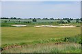
Open country south of Harwich
by David Kemp
The rising land in the distance marks the edge of the gridsquare. Taken from the Essex Way footpath which can be seen on the right.
|

|
The Essex Way 164: heading for the sea wall
South of Harwich.
|

|
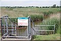
South Hall Sluice - the salty side of the sea wall
The actual sea is rather remote here, across a large expanse of saltings. Do not believe the grid reference quoted on the name plate - it is a typically slipshod Environment Agency effort, about 400 m out.
|
|
Wildfowler's Scrape
by Glyn Baker
I think this must be the "decoy pond" for the Little Oakley & District Wildfowlers Association. The association look after a considerable amount of the Hamford Water National Nature Reserve see TM2327 : Little Oakley & District Wildfowlers Association Marsh .
|

|
The Essex Way 166
The Essex Way is following the sea wall, giving good views all around - including these swans in the borrowdike.
|

|
Kissing gate on the Essex Way
by Glyn Baker
Looking towards Dovercourt on Footpath 177_30; at this point it is the Essex Way Link
|
|
South Hall Sluice
by Glyn Baker
The Environment Agency have rounded up their G.R into the next square East.
|

|
South Hall Creek With A Falling Tide
by Glyn Baker
Taken at TM2329 : South Hall Sluice
|

|
Borrow Dyke From the Essex Way
by Glyn Baker
Looking across the flatlands.
|

|
Essex Way and Hamford Water NNR Sign
by Glyn Baker
Looking towards Dovercourt
|

|
Essex Way heading away from The Coast
by Chris Heaton
Looking back over ground just covered.
The Essex Way takes a long straight course over fields away from the coast.
|

|
South Hall Creek
by Chris Heaton
One of many water channels that twist through the salt marshes on the northern section of the Hamford Water National Nature Reserve.
As seen from the Essex Way.
|

|
Southall Sluice
by Tim Heaton
Looking out over the northern part of Hamford Water National Nature Reserve
|

|
The Essex Way along Long Bank, Ramsey
by Roger Jones
This is the Essex Way long distance footpath.
|
|