Grid reference NN1794
near to Meall na h-Eilde [hill or Mountain], Highland, Great Britain
Coverage
We have
4 images
in grid square NN1794
Contribute
Explore gridsquare NN1794
Surrounding area
Maps
 Map © Crown Copyright")
TIP: Click the map for more Large scale mapping
Tip: Click the map to open the coverage map
We have
4 images
for NN1794

|
Sheep on the subsidiary summit of Meall na h-Eilde
by Anthony Cox
Here are some highland sheep on a subsidiary summit (681m - no name is given) of the mountain in the next square.
|
|
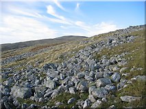
Stonefields, Meall na h-Eilde.
by Richard Webb
Stonefields caused by freeze thaw action on late iceage tundras. Looking NE to Meall na h-Eilde.
|

|
Towards Meall na h-Eilde
by Steven Brown
|

|
Old fence line on Meall Coire nan Saobhaidh
by Steven Brown
|
|