Grid reference NN1066
near to Bl�r a' Chaorainn, Highland, Scotland
Coverage
We have
14 images
in grid square NN1066
Contribute
Explore gridsquare NN1066
Surrounding area
Maps
 Map © Crown Copyright")
TIP: Click the map for more Large scale mapping
Tip: Click the map to open the coverage map
We have
14 images
for NN1066
|
West Highland Way, Blar a Chaorainn
This track forms a short spur of the West Highland Way giving access from the Fort William - Lundavra road.
|

|
Felled forest, Bl�r a' Chaorainn
by Richard Webb
Most of the forest at the north end of the Lairg M�r has recently been felled.
|

|
West Highland Way
by Steven Brown
The West Highland Way follows the route of an old military road.
|

|
Rough hillside above Bl�r a' Chaorainn
by Alan Reid
|

|
The Military Road, Bl�r a' Chaorainn
by Richard Webb
The old road from Kinlochleven to Fort William, passing through a felled area.
|

|
Meall a' Chaorainn
by Richard Webb
The west side of Meall a' Chaorainn rising above the felled forest near Bl�r a' Chaorainn.
|

|
Forestry track
by Nigel Brown
Also serving as a connection with the West Highland Way.
|

|
West Highland Way
West Highland Way heading to Blar a' Chaorainn
|

|
View towards Lochan L�nn D�-Bhr�
by Chris Heaton
Since the felling of the plantation, walkers can now enjoy a view up the glen formed by the River Kiachnish towards the lochan
|

|
West Highland Way above Bl�r a' Chaorainn
by Chris Heaton
For tired walkers heading towards Fort William, another challenge presents itself with a protracted climb through this felled plantation
|

|
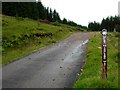
Junction at Bl�r a' Chaorainn
by John Allan
The mid-point of the walk between Kinlochleven and Fort William on the West Highland Way. Here, the Way leaves the old military road and takes the path ahead that climbs across to Glen Nevis.
|

|
The West Highland Way leaving the river valley
by Tim Heaton
Up to this point the Way has followed the Old Military Road from Kinlochleven along the river valleys linked at the Great Pass (Lairigmor). But now the Way has parted with the Road and the valley, and heads over high ground towards Glen Nevis.
|

|
Track linking a minor road to the West Highland Way
by Peter Wood
Looking south-eastward.
|

|
Forestry road near Lundavra
by Steven Brown
|
|