Grid reference TQ4260
near to London Biggin Hill Airport, Bromley, England
Coverage
We have
40 images
in grid square TQ4260
Contribute
Explore gridsquare TQ4260
Surrounding area
Maps
 Map © Crown Copyright")
TIP: Click the map for more Large scale mapping
Tip: Click the map to open the coverage map
Sample images
Breakdown list
images taken from TQ4260 [3]
A sample of 12 photos from 40
for TQ4260
- View this square in the Browser >>>

|
Twelfth fairway, West Kent Golf Club
You need to take at least a 5-iron for your second shot at the twelfth, or you will probably not clear this nasty bunker!
This is the last gridsquare in the TQ46 hectad to be geographed, I have done about half of these. So I shall be off... (more)
|

|
View across the golf course
This picture was taken from one public footpath, looking across the valley to another footpath as it disappears into the trees.
|

|
Aircraft wreckage at Biggin Hill, 1960
The aircraft in question was a Beech C18S Expeditor. According to a note I'd scribbled on the back of a print, the plane had burnt out on the ground at Hurn, Bournemouth. The wreckage was covered in red-brown stains, perhaps from... (more)
|

|
Footpath to Downe (set of 2 images)
by N Chadwick
|

|
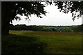
View across the course, West Kent Golf Club
by David Martin
The footpath from Downe to Biggin Hill crosses this very attractive golf course, mostly in a dry valley and surrounded by woodland.
|

|
Footpath through West Kent Golf Course
This tree lined path leads from Downe, through the course and Sow Wood (in the background) towards Biggin Hill.
On the left is the 9th Hole fairway, and on the right is the 7th Hole fairway.
|

|
Footpath junction
by Ian Capper
Junction of footpaths alongside West Kent Golf Course. The path on the left leads to Charles Darwin's House, Down House.
|

|
Countryside seen from the grounds of Down House (set of 2 images)
by Marathon
Down House was the home of Charles Darwin (1809 - 1882) who lived here for 40 years, from 1842 until his death. Down House was also home to Darwin's wife Emma, their ten children, domestic staff, and various pets and livestock.... (more)
|

|
Interior of pillbox
by Mike Stace
The pillbox was constructed around a tree, in an attempt to conceal it. Although the tree has died, the trunk is still inside.
|
|
View south from Darwin's Sandwalk
Darwin's "Sandwalk" runs from Down House to, and around, a nearby spinney.
|

|
Looking across the approach to the Sandwalk
by Marathon
Down House was the home of Charles Darwin (1809 - 1882) who lived here for 40 years, from 1842 until his death. Down House was also home to Darwin's wife Emma, their ten children, domestic staff, and various pets and livestock.... (more)
|

|
Biggin Hill Airport fence
These shining new posts are part of a new fence going up around the airport boundary beside Sow Wood.
A footpath leads beside the fence line and wood from Biggin Hill towards Downe Road (near Keston).
Sadly no views of the airport and runways!
|
Explore more images in this square: | View Filtering options | View all 40 images page by page >>> |
|