Grid reference TA1031
near to Bransholme, Kingston Upon Hull, England
Coverage
We have
445 images
in grid square TA1031
Contribute
Explore gridsquare TA1031
Surrounding area
Maps
 Map © Crown Copyright")
TIP: Click the map for more Large scale mapping
Tip: Click the map to open the coverage map
A sample of 12 photos from 445
for TA1031
- View this square in the Browser >>>

|
Silo, barge, River Hull
by Paul Harrop
Essentially the reverse view of the Isis Oil Mills silo as seen in TA1031 : Stoneferry silo, river and chimney, Hull, and at a similar early morning hour, though I think it might be a different barge
|

|
Leads Road, Kingston upon Hull
Klondyke Avenue, Nos.85 to 121 Leads Road, terrace of 18 similar dwellings, together with a more substantial house, with bay windows at both floors, at No.121. Built by 1908-09.
|

|
Bored
These buildings between West Carr Lane and the River Hull have been extensively tagged.
|
|
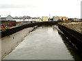
The River Hull southwards from Stoneferry Bridge
The River Hull is tidal at this point and can have quite strong currents in it at times. From this position, the River Hull is exactly two miles away (as the crow flies) from the River Humber into which it feeds, although a River Hull boat... (more)
|

|
River Hull (set of 8 images)
by N Chadwick
|

|
The Rear of Dove House Hospice, Hull
by Ian S
|

|
Twin lift bridges
A pair of modern bascule bridges carry the A1165 Clough Road across the R Hull. Looking N.
|

|
A path off Ferry Lane to the River Hull
by Ian S
|

|
Edward VII postbox on Chamberlain Road, Hull
by JThomas
Postbox No. HU8 127.
See TA1031 : Post Office and shop on Chamberlain Road, Hull for context.
|

|
Ferry Lane crosses Stoneferry Bridge
by Martin Dawes
Many years ago there was a ferry crossing here, the area over the bridge is Stoneferry.
|

|
Chamberlain Road, Hull
Looking in an easterly direction from MR: TA10823110.
|

|
Shops on Chamberlain Road
by DS Pugh
Looking along Chamberlain Road from the crossing of the Hornsea Rail Trail.
|
Explore more images in this square: | View Filtering options | View all 445 images page by page >>> |
|