Grid reference TA0735
near to Dunswell, East Riding of Yorkshire, England
Coverage
We have
89 images
in grid square TA0735
Contribute
Explore gridsquare TA0735
Surrounding area
Maps
 Map © Crown Copyright")
TIP: Click the map for more Large scale mapping
Tip: Click the map to open the coverage map
Sample images
Breakdown list
images taken from TA0735 [2]
A sample of 12 photos from 89
for TA0735
- View this square in the Browser >>>

|
River Hull near Dunswell
by David Brown
|

|
Farm buildings near Dunswell, East Yorkshire
by Ian S
|

|
Bus stop on the A1174, Dunswell
by JThomas
|

|
Across the River Hull towards new housing development at Kingswood
by Chris Morgan
|
|
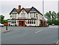
Chinese Restaurant or Public House?
by Peter Church
The Coach and Horses is also known as China Red.
|

|
Pylon beside the River Hull |

|
Path leading to Skidby Carr Lane (set of 2 images)
by Ian S
|

|
River Hull floodbank footpath heading north
by Martin Dawes
The white house in the distance is Entick House
|

|
River Hull, Dunswell
by Paul Harrop
Seen from close to the end of Ings Lane.
|

|
Dunswell war memorial
by Paul Harrop
Photograph taken on Remembrance Day (11 November), showing some of the additions to mark the occasion. The memorial is on Beverley Road outside the Dunswell Academy primary school.
|

|
Dunswell Lane
This view from the SW corner of the grid square looking north down the Beverley and Barmston Drain. The River Hull meanders in the SE corner of the square and the A1174 Beverley, Hull Road passes through.
|

|
Beverley and Barmston Drain
by Peter Church
From Dunswell Lane. The red brick bridge is Carr Lane bridge
|
Explore more images in this square: | View Filtering options | View all 89 images page by page >>> |
|