Grid reference TA0526
3 km from Anlaby, East Riding of Yorkshire, England
Coverage
We have
218 images
in grid square TA0526
Contribute
Explore gridsquare TA0526
Surrounding area
Maps
 Map © Crown Copyright")
TIP: Click the map for more Large scale mapping
Tip: Click the map to open the coverage map
Sample images
Breakdown list
images taken from TA0526 [11]
A sample of 12 photos from 218
for TA0526
- View this square in the Browser >>>

|
A63 Clive Sullivan Way
by Glyn Drury
|

|
Hessle Road from Pickering Road
by DS Pugh
Hessle Road forms part of National Cycle Network route 65, taking the path into Hull.
|
|
Sea size waves - on the River Humber!
The very strong westerly wind on this day was causing this!
|

|
Trans Pennine Trail heading west
by JThomas
|

|
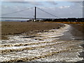
Mudflats on the Humber
by Peter Church
A slightly misty day so the Humber Bridge is not clearly visible from this distance.
|

|
Sunset, estuary and mud, near Hessle
by Paul Harrop
Looking west towards the Humber Bridge from the riverside path which forms part of the Trans Pennine Trail.
|

|
Trans Pennine Trail
With my back to the River Humber on my right is a former industrial area now derelict; ahead is Clive Sullivan Way and to my left is an area of reed beds.
|

|
The Trans Pennine Trail towards Hessle (set of 7 images)
by Ian S
|

|
Foreshore view towards the Humber Bridge from the A63
by Neil Theasby
|

|
Robinia Drive off Summergroves Way, Hull
by Ian S
|

|
The A63
by N Chadwick
|

|
Pharmaceutical facility, near Hessle
by Paul Harrop
The Chapleo Building, a research and development centre for international pharmaceutical firm Indivior Link
|
Explore more images in this square: | View Filtering options | View all 218 images page by page >>> |
|