Grid reference ST6103
near to Batcombe, Dorset, England
Coverage
We have
57 images
in grid square ST6103
Contribute
Explore gridsquare ST6103
Surrounding area
Maps
 Map © Crown Copyright")
TIP: Click the map for more Large scale mapping
Tip: Click the map to open the coverage map
A sample of 12 photos from 57
for ST6103
- View this square in the Browser >>>

|
Stile Way, near Batcombe |

|
Batcombe Church from Batcombe Hill |

|
Mixen, Batcombe Hill
by Richard Webb
Muck awaiting spreading on the downland plateau.
|

|
St Mary, Batcombe: Great War Memorial
by Basher Eyre
|

|
Downland in summer
Open access downland above Batcombe church
|

|
View across fields to Batcombe
by Peter Facey
From Stile Way, the steep single-track road that descends into Batcombe from the top of Batcombe Hill. Looking further right, see ST6103 : Batcombe Church from Batcombe Hill.
|
|
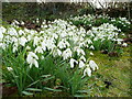
Snowdrops, Galanthus nivalis
A large colony in a shady corner of Batcombe churchyard.
The cold winter of 2009/10 has delayed the bloom well into March.
|

|
Grazing Heifers - Batcombe Hill
by Sarah Smith
A quiet pastoral scene with a dramatic backdrop showing the edge of the Blackmoor Vale in the distance.
|

|
East Hill, gate
by Mike Faherty
On the path to Up Sydling, skirting Sydling Woods.
|

|
West Hill trigpoint
Easily accessible on footpath.
|

|
Footpath near Batcombe
The footpath crosses a narrow field to reach a gate to take walkers to Whites Wood and Sydling Wood.
|

|
Batcombe Hill
by Richard Webb
The scarp above Batcombe.
|
Explore more images in this square: | View Filtering options | View all 57 images page by page >>> |
|