Grid reference ST6071
near to Knowle, Bristol, England
Coverage
We have
419 images
in grid square ST6071
Contribute
Explore gridsquare ST6071
Surrounding area
Maps
 Map © Crown Copyright")
TIP: Click the map for more Large scale mapping
Tip: Click the map to open the coverage map
Sample images
Breakdown list
images taken from ST6071 [13]
A sample of 12 photos from 419
for ST6071
- View this square in the Browser >>>

|
Ordnance Survey Cut Mark
by Adrian Dust
This OS cut mark can be found on the wall NW side of Brecknock Road. It marks a point 60.805m above mean sea level.
|

|
Bristol : Saint Phillips Greenway
by Lewis Clarke
A path following the River Avon.
|

|
St Mary Redcliffe cemetery
by Neil Owen
This site is quite some distance from the actual parish church of St Mary. Opposite is the major garden cemetery of Arnos Vale - a private company that opened in the 1830s as a burial ground for all, and easing the pressures on inner city... (more)
|

|
Sparke Evans Park
by Derek Harper
From the River Avon Trail, which runs along the river side of the park.
|
|
Arno's Vale Cemetery : Non-Conformist Chapel
by Dave Napier
The Non-Conformist Chapel is one of two in Arno's Vale Cemetery. This neglected Victorian cemetery has been looked after by a dedicated group of 'Friends' for the past 15 years and recently a successful �5m lottery bid means... (more)
|

|
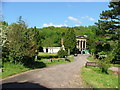
Speilman Centre, Arnos Vale Cemetery
by Eirian Evans
Venue for weddings etc. at the cemetery!
|

|
Benchmark (?) on wall at #206 Wells Road
Site of Ordnance Survey cut mark benchmark which is described on the Bench Mark Database at Link
|

|
River Avon at St Philip's Marsh, Bristol
From the footbridge.
|

|
River Avon from Totterdown Bridge |

|
Top of Summer Hill, Totterdown, Bristol
by Jaggery
Summer Hill descends from the corner of Goolden Street.
The triangular sign on the left shows a gradient of 25% (1 in 4).
|

|
Fuel tanks with faces, St. Philip's Marsh, Bristol
by Gareth James
|

|
Mural of the 1831 Bristol Riots #4
by Neil Owen
Another section of the mural depicting the sad events of Bristol's history.
|
Explore more images in this square: | View Filtering options | View all 419 images page by page >>> |
|