Grid reference ST5394
near to Tutshill, Gloucestershire, England
Coverage
We have
843 images
in grid square ST5394
Contribute
Explore gridsquare ST5394
Surrounding area
Maps
 Map © Crown Copyright")
TIP: Click the map for more Large scale mapping
Tip: Click the map to open the coverage map
A sample of 12 photos from 843
for ST5394
- View this square in the Browser >>>

|
Road and rail in parallel
The A48 and railway line sharing the crossing of the River Wye, viewed from Tutshill. Chepstow town arranged in the background.
|

|
Telecoms cabinets on grass, Tutshill, Gloucestershire
by Jaggery
Alongside Beachley Road.
|

|
Entering England
The old bridge over the River Wye at Chepstow marks the border between Monmouthshire and Gloucestershire - Wales and England. This narrow road, which after crossing the river winds its way up to Tutshill, was once the A48 - the principal... (more)
|

|
Bunting
by Alan Hughes
A view of Chepstow Castle.
|

|
Chepstow Castle, Chepstow, Monmouthshire taken 1965
Approaching Chepstow Castle.
Chepstow is a Norman castle perched high above the banks of the river Wye in southeast Wales. Construction began at Chepstow in 1067, less than a year after William the Conqueror was crowned King of England.... (more)
|

|
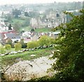
Corner of Chapelhouse Wood, Tutshill |
![ST5394 : Chepstow houses [50] by Michael Dibb](https://s3.geograph.org.uk/geophotos/07/35/84/7358431_6bff61af_120x120.jpg)
|
Chepstow houses [50]
by Michael Dibb
Number 37 and 37 Lower Church Street have been vacant since 2020 when an explosion and fire destroyed number 38.
Chepstow, the most easterly town in Wales, is located on the tidal River Wye, some 3 miles above its confluence with the River... (more)
|

|
Chepstow - Old and New Bridges |

|
River Wye from Chepstow Castle
Houses near Tutshill can be seen on the other side.
|

|
Tidal Wye at Chepstow
by Pauline E
The Wye forms part of the national boundary of England and Wales at this point. This is taken from the Welsh side, Monmouthshire, looking upstream on a dull, drizzly Sunday in February. The Wye is tidal at this point and the muddy river... (more)
|
|
Chepstow Castle from across the Wye
by Graham Horn
On a dreary day to start the Offa's Dyke Path.
|

|
Bridge Street, Chepstow |
Explore more images in this square: | View Filtering options | View all 843 images page by page >>> |
|