Grid reference ST1868
near to Lavernock, The Vale of Glamorgan/Bro Morgannwg, Wales
Coverage
We have
77 images
in grid square ST1868
Contribute
Explore gridsquare ST1868
Surrounding area
Maps
 Map © Crown Copyright")
TIP: Click the map for more Large scale mapping
Tip: Click the map to open the coverage map
A sample of 12 photos from 77
for ST1868
- View this square in the Browser >>>

|
Cliff top path
by Alan Hughes
In the distance clouds are gathering over Flat Holm.
|

|
Marconi - Kemp Plaque at Lavernock
by Colin Smith
Sited outside the church at Lavernock. The more famous Marconi sent his first overseas wireless transmission from here to Flat Holm in the Bristol Channel, about 5 kilometres to the south-east, in 1897.
|

|
Wales Coast Path
by Eirian Evans
To the left there is a drop of 20+ metres to the sea at Ranny Bay.
|

|
Tower at Lavernock Point
Looking south along the coast path towards Steepholm island (right) and Flatholm island (left). On the right is a small tower - not sure what it might have been used for.
|

|
Cliffs west of Lavernock Point
by Dylan Moore
The Blue Lias here dips slightly south-westward, and successively higher limestone bands form ridges on the beach.
|

|
View towards Lavernock
The field is adjacent to the Wales Coast Path which passes through the trees to the left. Ahead is Lavernock Point and the Bristol Channel.
|

|
Lavernock Point
by Penny Mayes
On May 13, 1897, Marconi transmitted the first wireless signals over water from the top of this cliff to Flatholm Island (out of shot, that's Steep Holm in the distance).
|

|
Looking out to sea from Lavernock Point
by Gareth James
Flat Holm and Steep Holm islands are visible.
|

|
St.Lawrence Church, Lavernock
by Alan Hughes
An interesting insight: Link
|

|
Lavernock Point nature reserve (set of 3 images)
by Gareth James
|

|
Headland north of Lavernock Point
by Dylan Moore
Here red Keuper Marl emerges from under the pale green Blue Anchor Formation. Together these are part of the "Mercia Mudstone Group".
|
|
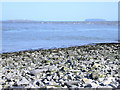
Lavernock Point
Looking across the Bristol Channel to the islands of Flat Holm and Steep Holm.
|
Explore more images in this square: | View Filtering options | View all 77 images page by page >>> |
|