Grid reference ST1388
near to Abertridwr, Caerphilly/Caerffili, Wales
Coverage
We have
32 images
in grid square ST1388
Contribute
Explore gridsquare ST1388
Surrounding area
Maps
 Map © Crown Copyright")
TIP: Click the map for more Large scale mapping
Tip: Click the map to open the coverage map
Sample images
Breakdown list
images taken from ST1388 [1]
A sample of 12 photos from 32
for ST1388
- View this square in the Browser >>>

|
Heol Brynawel Road
Cerddwyr yn anelu at Heol Brynawel.
Walkers aim ing for Brynawel Road.
|

|
Ordnance Survey Cut Mark
by Adrian Dust
This OS cut mark can be found on No1 Thomas Street. It marks a point 145.088m above mean sea level.
|

|
Nant-yr-Aber valley near Penyrheol, Caerphilly
by Jaggery
A view to the SW from the B4263 into the valley of a stream, Nant-yr-Aber.
|

|
Community Centre
by Peter Wasp
Penyrheol Community Centre, Caerphilly.
|

|
Ty Isaf
by Alan Hughes
Housing at Penyrheol.
|

|
Commercial Motors (UK) Ltd, Abertridwr
by John Lord
|

|
Road to Hendrenny-ganol |

|
Weir on Nant Aber
by M J Roscoe
Small weir just before the river turns to go underneath the Aber Cycleway (camera position).
|

|
Unnamed side road in the southeast of Abertridwr
by Jaggery
Ascending from the northeast side of the B4263.
|

|
Bowles Close, Caerphilly |
|
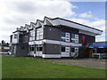
Aneurin Social Club, Penyrheol |

|
Rural section of the B4263 SE of Abertridwr
by Jaggery
This is part of a 700-metre long stretch of the B4263 between Penyrheol and Abertridwr that uses a narrow shelf through sloping land in the Nant-yr-Aber valley. Adjacent to the road, there is no land flat enough for houses.
|
Explore more images in this square: | View Filtering options | View all 32 images page by page >>> |
|