Grid reference ST0889
near to Glyntaff, Rhondda Cynon Taf, Wales
Coverage
We have
221 images
in grid square ST0889
Contribute
Explore gridsquare ST0889
Surrounding area
Maps
 Map © Crown Copyright")
TIP: Click the map for more Large scale mapping
Tip: Click the map to open the coverage map
Sample images
Breakdown list
images taken from ST0889 [11]
A sample of 12 photos from 221
for ST0889
- View this square in the Browser >>>

|
Rocket Residential lettings office in Treforest
by Jaggery
Independent lettings agents at 72 Park Street Treforest.
|

|
St. Dyfrig's Church, Treforest |
|
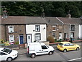
Terraced houses in Pentrebach Rd, Pontypridd
by John Lord
The plaque on the house third from the left is inscribed:
Oddfellows Place
Pontypridd
MDCCCLII
|

|
A470 at Glyntaff
by Colin Pyle
|

|
Bridge over the Taff in Treforest
by Gareth James
|

|
Glyntaff Crematorium
by Bilbo
|

|
Ynysangharad Rd meets Merthyr Rd, Pentrebach
by Kev Griffin
|

|
Gateway to Glyntaff cemetery
by David Smith
|

|
No Parking in Cambrian Place, Treforest
by Jaggery
Double yellow lines on both sides of Cambrian Place indicate no parking at any time.
From the A473 Broadway on the camera side, Cambrian Place leads to Cyrch-y-gwas Road.
|

|
View across to Treforest
by Gareth James
Viewed from the hillside above Glyntaff cemetery, looking towards the university buildings on the other side of the valley.
|

|
Glyntaff cemetery & crematorium grounds
by Gareth James
|

|
Ordnance Survey Cut Mark
by Adrian Dust
This OS cut mark can be found on No48 Pentrebach Road. It marks a point 61.481m above mean sea level.
|
Explore more images in this square: | View Filtering options | View all 221 images page by page >>> |
|