Grid reference ST0568
near to Penmark, The Vale of Glamorgan/Bro Morgannwg, Wales
Coverage
We have
25 images
in grid square ST0568
Contribute
Explore gridsquare ST0568
Surrounding area
Maps
 Map © Crown Copyright")
TIP: Click the map for more Large scale mapping
Tip: Click the map to open the coverage map
Sample images
Breakdown list
images taken from ST0568 [1]
A sample of 12 photos from 25
for ST0568
- View this square in the Browser >>>

|
Penmark Castle
by John Lord
Photo taken from farm track to the west of the castle
|

|
Church Gate, Penmark
by Tony Hodge
|

|
Six Bells, Penmark
by Alan Hughes
The Six Bells in the village of Penmark.
|

|
B4265 at Penmark turn
by Colin Pyle
|

|
Church of the Blessed Virgin Mary, Penmark
One of the largest medieval churches in the Vale of Glamorgan. The church dates from the 12th century whilst the Tower and some other features were added in the 15th century. The restoration of 1860 replaced the windows whilst the final... (more)
|

|
Ordnance Survey Rivet
by Adrian Dust
This OS rivet can be found on the stile SE side of the road. It marks a point 46.144m above mean sea level.
|
|
Summer flood Penmark
by Mick Lobb
|

|
Ger Penmarc / Near Pen Mark
Cerddwyr wedi gadael pentre Penmarc ac yn dilyn llwybr cyhoeddus tuag at heol fach.
Walkers having left the village of Penmark heading towards a minor road.
|

|
The Church of the Blessed Virgin Mary, Penmark |

|
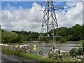
East of Penmark - Vale of Glamorgan
The pylons come from the Aberthaw generating station and branch up the Kenson valley.
|

|
Ordnance Survey Cut Mark
by Adrian Dust
This OS cut mark can be found on the barn at The Mount. It marks a point 37.713m above mean sea level.
|

|
Penmark Farm
by John Lord
|
Explore more images in this square: | View Filtering options | View all 25 images page by page >>> |
|