Grid reference SO8271
near to Wilden, Worcestershire, England
Coverage
We have
159 images
in grid square SO8271
Contribute
Explore gridsquare SO8271
Surrounding area
Maps
 Map © Crown Copyright")
TIP: Click the map for more Large scale mapping
Tip: Click the map to open the coverage map
A sample of 12 photos from 159
for SO8271
- View this square in the Browser >>>

|
Sunrise near Stourport
by Gareth James
|

|
Hartlebury Common
by David Dixon
Hartlebury Common is situated on the edge of Stourport on Severn and is owned and managed by Worcestershire County Council. As a Site of Special Scientific Interest (SSSI) it is one of the few remaining examples of Lowland Heath in the... (more)
|

|
Treescape on Hartlebury Common
Looking across a rather dry-looking common towards the car park and distant housing on Hartlebury Road. A very popular area with dog-walkers, apparently.
|

|
Common View
The view of Hartlebury Common SSSI near Stourport on Severn.
|
|
Hartlebury Common
by Martyn B
An area of lowland heath. Picture taken from grid ref SO 82651 71379, approx. 50 metres west of the trigpoint, looking SSW along the public footpath.
|

|
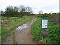
Steps up to Leapgate Country Park
by P L Chadwick
These steps give access to the country park from Wilden Lane. They are actually located on the edge of the car park of The Rock Tavern. SO8171 : Leapgate Country Park.
|

|
Stourport Manor Hotel
by Mike Dodman
See also Link from a different angle.
|

|
Former off-licence and shop (5), 77 Mill Road, Stourport-on-Severn, Worcs
by P L Chadwick
This is the view of the former off-licence and shop from The Spinney. The vegetation is so out of control that not a great deal can be seen. However there does seem to have been some kind of tower structure, which possibly dates from when... (more)
|

|
Leapgate Country Park in snow
by P L Chadwick
A large section of the former railway line to Stourport-on-Severn is now a linear country park, known as Leapgate Country Park. It was snowing heavily when this view was taken.
|

|
Wilden Lane from old railway bridge
by Jeff Gogarty
|

|
Scrub by Stourport Manor
by Bill Boaden
Higher ground overlooking Stourport-on-Severn, though there aren't many significant features to see.
|

|
Former railway viaduct across the River Stour
by Mat Fascione
The viaduct carried a former railway line to Stourport-on-Severn. It now forms part of a linear country park called Leapgate Country Park. It is also part of National Cycle Route 45.
|
Explore more images in this square: | View Filtering options | View all 159 images page by page >>> |
|