Grid reference SJ3157
near to Caergwrle, Flintshire/Sir y Fflint, Wales
Coverage
We have
17 images
in grid square SJ3157
Contribute
Explore gridsquare SJ3157
Surrounding area
Maps
 Map © Crown Copyright")
TIP: Click the map for more Large scale mapping
Tip: Click the map to open the coverage map
Sample images
Breakdown list
images taken from SJ3157 [1]
A sample of 12 photos from 17
for SJ3157
- View this square in the Browser >>>

|
Bus stop and shelter on Gresford Road (B5373)
by JThomas
Looking north west.
|

|
The junction of Gresford Road and Caer Estyn
by Eirian Evans
|
|
Ancient track near Bridge End, Caergwrle
Taken on the public footpath/track that crosses the hill above Bridge End. It seems to be ancient and designed to avoid the low ground alongside the River Alyn.
|

|
Barn at Bridge End
by John H Darch
|

|
Stile on the footpath on Wat's Dyke in Hope
This stile sits on the footpath that runs along this section of the dyke, between horse paddocks and the back gardens of adjacent homes.
|

|
Lane
This lane leads to the Spa now a private residence.
|

|
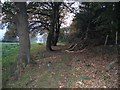
Chestnut Woods |

|
Caergwrle houses
by Eirian Evans
On Rhyddyn Hill on the outskirts of Caergwrle. Bryn y Gaer is the wooded area to the rear of the houses.
|

|
Bridge End Caergwrle
I'm not sure the correct name for these gates. I call them sluice gates for the old water mill.
|

|
Access road to New Farm |

|
Wat's Dyke
It's not obvious, but this footpath runs along the top of the ancient boundary known as Wat's Dyke. On the other side of the trees on the right, there is a significant drop to the field below.
|

|
Three way stile
Not for the indecisive amongst us.
|
Explore more images in this square: | View Filtering options | View all 17 images page by page >>> |
|