Grid reference SH7358
near to Pont Cyfyng, Conwy, Wales
Coverage
We have
43 images
in grid square SH7358
Contribute
Explore gridsquare SH7358
Surrounding area
Maps
 Map © Crown Copyright")
TIP: Click the map for more Large scale mapping
Tip: Click the map to open the coverage map
Sample images
Breakdown list
images taken from SH7358 [2]
A sample of 12 photos from 43
for SH7358
- View this square in the Browser >>>

|
Stream across path
The Nant y Geuallt crosses the footpath at this point.
|

|
Nant y Geuallt
by Ian Greig
|

|
Bog Myrtle on the hillside below Waenhir
by Richard Law
Open moorland dominates this hillside between Capel Curig and the small hut at Waenhir which lies near the rocky outcrop in the distance. In the foreground here, a Bog Myrtle plant (Myrica gale) is sprouting up; its leaves are edible, and... (more)
|
|
Footpath through Lower Cwm Geuallt
by Eric Jones
The footpath follows a drier shelf above the flat valley floor. Even so, in wet weather, the path can be very waterlogged. The Coed Bryn-engan Forest and Moel Siabod form the background.
|

|
Footbridge above Capel Curig
by Ron Galliers
On the walk back from Llyn Crafnant, just before you start the descent into Capel Curig with views towards the Snowdon Horseshoe.
|

|
Nant y Geuallt
by Ceri Thomas
|

|
Llwybr wedi ei adnewyddu / Restored path, Capel Curug
Gwelliannau ar lwybr a fu'n wlyb iawn yng Nghapel Curig. Y fan yn y pellter yw Moel Siabod.
Recent improvements to a once boggy footpath in Capel Curig. The peak in the distance is Moel Siabod.
|

|
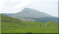
Cwm Geuallt
by dave roberts
This picture clearly shows the boggy area in the square and the hills (beyond the square)
|

|
New footbridge over Nant y Geuallt
by Eirian Evans
|

|
Nant-y-Geuallt
The stream runs down this valley and is crossed a couple of times by small footbridges. To the left of the photo can also be seen the edge of Clogwyn-mawr. the picture was taken looking SW towards Capel Curig in the distance.
|

|
Path protected from erosion - the old way
There is controversy (in 2022) about the National Park's heavy-handed treatment of the Crafnant bridleway. This is a good example of previous, landscape sensitive, work using natural stone. See other photos for the modern process.
|

|
Moor and woodland below Clogwyn Cigfran |
Explore more images in this square: | View Filtering options | View all 43 images page by page >>> |
|