Grid reference SH3176
near to Dowyn, Isle of Anglesey/Sir Ynys Mon, Wales
Coverage
We have
34 images
in grid square SH3176
Contribute
Explore gridsquare SH3176
Surrounding area
Maps
 Map © Crown Copyright")
TIP: Click the map for more Large scale mapping
Tip: Click the map to open the coverage map
Sample images
Breakdown list
images taken from SH3176 [4]
A sample of 12 photos from 34
for SH3176
- View this square in the Browser >>>

|
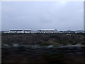
The railway alongside RAF Valley |

|
Paved way across roughly vegetated land
The land lies to the east of the airfield of RAF Valley; it's also access land. The long, rather dowdy looking building at the left side of the image surely has a connection to the RAF - the roads beyond it and among other buildings... (more)
|
|
Buildings at RAF Valley
Accommodation buildings at RAF Valley
|

|
Married Quarters, RAF Valley
by Eric Jones
|

|
Llyn Penrhyn |

|
From a Chester-Holyhead train - Dowyn sports facilities |

|
Llyn Penrhyn
by Eric Jones
|

|
The road near Llyn Penrhyn |

|
Maes Awyr Mon/Anglesey Airfield
by Eric Jones
This is the terminal for civilian flights within RAF Valley.
|

|
Ysgol y Tywyn Primary School, RAF Valley
by Eric Jones
The campus of this LEA run school is located within the Domestic Site of RAF Valley
Link
|

|
Spar Store and Police Station, RAF Valley
by Eric Jones
|

|
Contrast either side of the Holyhead-London railway
by Eric Jones
To the left of the line is a part of the extensive Tywyn Trewan and to the right is the RAF Valley airfield. Up to the 1940s both sides of the line would have looked the same.
|
Explore more images in this square: | View Filtering options | View all 34 images page by page >>> |
|