Grid reference SE2125
near to Birstall Smithies, Kirklees, England
Coverage
We have
62 images
in grid square SE2125
Contribute
Explore gridsquare SE2125
Surrounding area
Maps
 Map © Crown Copyright")
TIP: Click the map for more Large scale mapping
Tip: Click the map to open the coverage map
Sample images
Breakdown list
images taken from SE2125 [7]
A sample of 12 photos from 62
for SE2125
- View this square in the Browser >>>

|
A stile on the path from Stubley Farm Road to Muffit Lane
by habiloid
|

|
Track to Barley Fields Farm
A track off Oxford Road which is a public footpath
|

|
Grazing off Leeds Road, Heckmondwike
by JThomas
|

|
Popeley Farm
by John Slater
|

|
Popeley Rise, Gomersal |

|
Pressed for Time - Oxford Road |

|
Church Well, Garfitt Hill
See SE2125 : Church Well, Garfitt Hill for a closer view.
|

|
Former workhouse in Gomersal
by Nigel Auty
This is the former workhouse in Gomersal, now a row of houses.
|

|
Popeley Farm, Gomersal
Viewed from Oakwell Country Park just over a mile away.
|
|
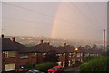
Craven Close looking towards Birstall
by Chris-Bel
Rainbow over Birstall and towards Drighlington viewed from Hill Top - Gomersal.
|

|
Gomersal
The hill top village about 10 miles south of Leeds. Looking towards Bradford on the road which leads to Heckmondwike
|

|
Sunset over Birstall from Hill Top Gomersal
by Chris-Bel
Autumn sunset from Craven Close view towards Birstall down Church Lane
|
Explore more images in this square: | View Filtering options | View all 62 images page by page >>> |
|