Grid reference SD8715
near to Broadley, Lancashire, England
Coverage
We have
30 images
in grid square SD8715
Contribute
Explore gridsquare SD8715
Surrounding area
Maps
 Map © Crown Copyright")
TIP: Click the map for more Large scale mapping
Tip: Click the map to open the coverage map
A sample of 12 photos from 30
for SD8715
- View this square in the Browser >>>

|
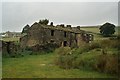
Derelict mill site on Dell Road
by Bill Boaden
There are signs suggesting these premises were in multiple occupation before becoming empty.
|

|
Modern & WWII Pole Barriers
Modern concrete block across Dell Road and WWII pole barrier still surviving from when the mill beyond was a munitions filling factory.
|

|
White Lees, near Norden, Rochdale, Lancashire
This stone farmhouse probably dates from the early eighteenth century.
|

|
Old Guide Stone by Rooley Moor Road, near Catley Lane Head
Guide Stone by the UC road, in parish of Rochdale (Rochdale District), Catley Lane Head, 30m North of last house (No. 607) in Rooley Moor Road.
Surveyed
Milestone Society National ID: LA_XROC01
|

|
No Ding Quarry
by michael ely
This sign on an old shed is by the side of Rooley Moor Road at Catley Lane Head.
Ding Quarry (stone quarry) has been unused for years but there is a planning application before Rochdale BC to re-open it. This will generate heavy traffic on... (more)
|

|
Nissen hut
by Phill
Nissen Hut by old munitions factory, Healey Dell.
|

|
Rooley Moor Road
A view southerly, down Rooley Moor Road towards Smallshaw and Catley Lane Head, just north of Caldershaw in Rochdale, Greater Manchester, England.
|

|
Smallshaw Farm, Smallshaw Road, Rochdale
Dated 1632 on the projecting porch; built for James Crossley. Grade II listed.
|

|
King's Bridge, Catley Lane Head
by David Dixon
See SD8715 : Derelict cottages at Lanehead for a similar view of these cottages 25 years earlier.
|

|
Rowan Close, Rochdale
by ethics girl
View of houses in Rowan Close and Stonehill Road from Fern Hill. The 'Seven Sisters' tower blocks can be seen in the distance, with the Pennines and Peak District beyond.
|

|
Sorry, no mod cons...
See SD8715 : Derelict cottages at Lanehead, Rochdale, Lancashire. It's OK in summer, but February??
|
|
Derelict cottages at Lanehead, Rochdale, Lancashire
A desirable situation right on the edge of moorland - but nobody wants them!
|
Explore more images in this square: | View Filtering options | View all 30 images page by page >>> |
|