Grid reference SZ6093
near to Ryde, Isle of Wight, England
Coverage
We have
5 images
in grid square SZ6093
Contribute
Explore gridsquare SZ6093
Surrounding area
Maps
 Map © Crown Copyright")
TIP: Click the map for more Large scale mapping
Tip: Click the map to open the coverage map
We have
5 images
for SZ6093
|
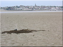
Tidelands near Ryde
View from Ryde East Sands towards Ryde. The image was taken during low tide, and the stone in the foreground, on which a bunch of algae is growing, has been dragged out towards the sea by the receding tide and left a skidmark.
|

|
Low tide on East Ryde Sands
The receding tide reveals East Ryde Sands, just visible in the distance is Horse Sands Fort and No Man's Land Fort, defence forts defending the entrance to the Solent.
|

|
Piggy-back ride at low tide
Looking across the shallow tide pools off Ryde's canoe lake.
|

|
Southsea - Ryde hovercraft
by Ian Capper
"Solent Express", the newest of three hovercrafts operated by Hovertravel, having entered service in 2007, approaches Ryde near the end of its 10 minute crossing from Southsea. Prominent in the background is the Spinnaker Tower... (more)
|

|
Looking Across Ryde East Sands To Portsmouth's Spinnaker Tower
by dinglefoot
Low Tide at Ryde East sands
|
|