Grid reference SH5172
near to Llanfair Pwllgwyngyll, Isle of Anglesey/Sir Ynys Mon, Wales
Coverage
We have
18 images
in grid square SH5172
Contribute
Explore gridsquare SH5172
Surrounding area
Maps
 Map © Crown Copyright")
TIP: Click the map for more Large scale mapping
Tip: Click the map to open the coverage map
Sample images
Breakdown list
A sample of 12 photos from 18
for SH5172
- View this square in the Browser >>>

|
Houses at Star |

|
Lane leading from Star towards the footbridge over the A55
by Eric Jones
This lane is part of the No 8 National Cycle Route.
|

|
Farmland near Star
Sheep graze with a background of snow covered mountains.
|

|
Road Junction at Star
This road from star is now part of the national cycle route no 8 across Anglesey which runs on quiet country lanes
|

|
Minor road towards Star
by JThomas
|

|
Between the hedgerows
by Eric Jones
Country road west of Star.
|

|
Entrance to the new access lane leading to Garnedd Ddu and Garnedd Isaf
by Eric Jones
|

|
The western approach to the hamlet of Star
by Eric Jones
|

|
View across the A55 (hidden) and fields towards the village of Star
by Eric Jones
The A55 here runs through a cutting
|

|
Deteriorating road conditions
by Eric Jones
|

|
The chapel and vestry at Penygarnedd (Pencarneddi) from a bend in the road
by Eric Jones
|
|
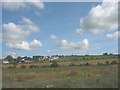
The village of Star from the A5
by Eric Jones
|
Explore more images in this square: | View Filtering options | View all 18 images page by page >>> |
|