Grid reference SO2957
near to Kington, County of Herefordshire, England
Coverage
We have
14 images
in grid square SO2957
Contribute
Explore gridsquare SO2957
Surrounding area
Maps
 Map © Crown Copyright")
TIP: Click the map for more Large scale mapping
Tip: Click the map to open the coverage map
We have
14 images
for SO2957

|
Offa's Dyke path approaching Kington |

|
Offa's Dyke Path approaching Bradnor Green
by Tim Heaton
|

|
End of Prospect Road
I think this may well have been the end of Prospect Road before the new road cut it in two, the road would have gone through a ford at one time.
|

|
Offa's Dyke Path crossing Kington Golf Club
Signs warn sleepy walkers to be aware of whizzing golf balls as they cross the fairway.
|

|
Kington
by Tom Courtney
A photo of Kington from Offa's Dyke Path from the north looking southeast. It's taken from about SO292574 from below Bradnor Green.
|
|
Kington Golf Course, Bradnor Hill
by Tim Heaton
Claiming to be the highest golf course in England.
|

|
A44 Kington bypass
West of a cutting the ground on the right opens up for a short distance.
|

|
Barton Farm, Kington
by Jim Barton
There are over 20 places in the UK with which I share my name, which is said to mean 'barley farm'. My favourite is Barton-in-the-Beans in Leicestershire.
The date of 1872 appears by the gate on this farm on the hillside above Kington.
|

|
Footpath sign, Barton
by Jim Barton
Kington brands itself as 'The centre for walking' with the Herefordshire Trail, Mortimer Trail and Offa's Dyke path passing through, plus a good network of local paths with signs such as these, erected by the Kington Footpath Scheme.
|

|
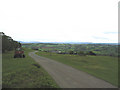
Minor road heads away from Kington
by Jaggery
Beyond the northern end of Prospect Road, a minor road climbs away from the A44.
The Kington boundary sign Link is behind the camera.
|

|
Offas Dyke Path on Bradnor Hill |

|
Barton Farm Kington
by paul wood
|

|
Bradnor Green
by paul wood
The Tiny Hamlet of Bradnor Green on Bradnor Hill overlooking Kington
|

|
Tuat ag / Towards Kington
Llwybr Clawdd Offa yn mynd i gyfeiriad tref Kington yn y pellter.
Offa's Dyke Path heading in the direction of Kington in the distance.
|
|